Wednesday, July 31, 2013

Day 45 - Lima, pronounced like the bean

Zero day in Lima. We've been so focused on the route down to here, we needed a day to sort ourselves out with regards to our trip through Yellowstone, and across the WY border.

And, we need to eat. In the last section, Gangles had been having strange symptoms: the spins (dizziness), nausea, loss of appetite, inability to sleep. When we got to Lima, we were happy to see SLAM!, who had the same symptoms. Apparently, she had altitude sickness, which is not uncommon for Sobos, due to the climb from Bannock Pass (~7500') to Elk Mountain (>10,000'). Since we were trying to do ~26mi / day, and succeeding except when derailed by route finding and inclement weather, Gangles is fine. She is strong enough to do the miles, but has been uncomfortable. So, we need a little R&R before the next section, both sleep and food.

And, we did a little back of the envelope math. We are probably eating ~2,500 calories per day on the trail, from all the oatmeal, protein bars, tuna, bread, pasta throughout the day. This is a pretty burly level of consumption. Physically, I'm not sure how much more I can handle, given the volume constraints on my stomach. But, we also estimated our daily energy expenditure around 4,000 calories (~1,600 for basic needs, i.e., what we need if we're in a coma, and then 100 calories / mi). We can't figure out why we feel fine, if we're running such a caloric deficit. (I think the 100 calories per mile is a decent estimate, since that's a rule of thumb for running a mile. While we're walking, we're navigating up / down terrain while carrying a pack). In towns, though, we do try to make up the calories, and probably consume ~6,000 calories. Which is both necessary and a real gut buster. We try to eat every 2 hours or so, to keep the supply of energy coming. And it works. The days out of town, we usually feel the strongest, and best rested.

As a testament to the difficulty of this trail vs. the AT or PCT, we are already eating more on this trail ~700mi in as we did at the end of the PCT. And I think we've both lost weight. I think it's almost time for us to pop over to Jan's cafe for some afternoon pie. Let the re-feed continue!

p.s., Thanks to Maron and Gloria for the wonderful care packages. Gloria, appreciate the Graceland souvenirs + things you found in your cupboards at home. Maron, the randomness is always so delicious. Biscoff cookies! It'll be just like flying Delta Airlines. From the Continental Divide Trail. I can almost recline my seat 4" if I imagine...

p.p.s., Should be at Old Faithful Village by 8/5

Mileage: Big fat zero (emphasis on the 'fat'. then the 'zero', and then the 'big' to complete the set)

Day 44 - so far, so good

What a beautiful morning. Though the campsite was not great--lots of cow pies, the morning was gorgeous. Blue skies and clear sight into the rolling hills of Southern Montana / Idaho. For the past few weeks, we've been walking along the border of the two states, on one multi-purpose line: the trail, the MT-ID state border, state-private land border, and the Continental Divide separating the Atlantic and Pacific watersheds.

The morning was a nice rolling hike over to Little Shineburger creek. At this point, the map shows a dashed line, which indicates that the trail isn't fully "official". And just as a man plummeting from the top of a skyscraper may say to himself as he passes each floor, "so far, so good". Our dose of reality was the the next section of trail, not clearly defined, but simply: find a way back from Little Shineburger creek up to the Divide. We found the creek, no problem, and traversed across the beginning of the ridge. We knew we had to follow the creek running up to the ridge, and started walking on nicely defined trail. The trail disappeared in some meadows, to reappear in sections, all the while relatively flat. We were most likely on some game trails, given the flatness of the trail, and the random scattering of large ungulate bones.

The real fright was the steep, looming peak ahead. We kept walking along the creek, which was narrowing at the headwaters, and finally disappeared into a dry bed of motley sized pebbles. And then, we saw, we had a major climb up over the next 0.8mi for so to the top of the ridge. Normally, this wouldn't be so bad, except... for the terrible prickers. I'm not sure of the technical name for these things (burrs, stickers, pokey things), but these are the flowers of a scrubby plant ubiquitous on these hillsides. The pricker are lime green when young and a pale yellow when dry and at their prickliest. They resemble 3D asterisks and are very tacky. The only part of me which repelled them were my Gore-Tex gaiters, but I was otherwise covered. I couldn't go very far without removing them, since they penetrated my pants, and scratched me at every step. The bushwhack up to the Divide was studded with these irritants. Add the steepness of the climb and the sun beating down, it was a relief when we were finally on the ridge. The views of the countryside were thrilling--we could see I-15 from miles away, as the 18-wheelers looked like small white rectangles sliding across the horizon.

And then we started the roller coaster, of ridge to ridge, following the barbed wire fence. We started off with gusto, tackling the first few ridges, and then ran into our next set of Nobos, Why Wait and Rob Steady. We were up on the barren ridge for the next 10mi or so, and they had just lunched in a small stand of three gnarled pines a half mile away. Just as we were wishing each other bon voyage, the rain moved in. Expecting this to be a short, limited burst, Gangles and I hiked on. Now, one of the benefits of being on a ridge is that you can see so far, and unfortunately, we could see no end to the dark clouds. The downside of being on a ridge is the danger of thunderstorms, both rain / wind exposure and lightning. We quickly bailed to the trees where Why Wait and Rob Steady had lunch.

The trees provided much better cover, and we were mostly shielded. We had lunch, and were just going to wait out the storm, but it continued to intensify. We pulled on our ponchos, and sat with our packs under the trees. The rain worsened, and turned into pelting hail, with no end in sight. We were getting cold, and feared hypothermia, so we decided we should pitch our tent. The hardest part was emerging from my poncho cave. We managed to very badly pitch on the steep slope. and crawl inside. The winds and rain were howling outside, and we had to re-stake a few times, as the tent was being uprooted from the winds. After ~1.5h in total, the rain blew over, and the skies were blue. Montana's weather motto: If you don't like the weather, don't worry, it'll change!

Now, way behind schedule, we packed hurriedly and hustled back out on the ridge. The roller coaster was fun, but began the toll of the bushwhack and hail storm began to wear on us. We were still hoping to get in tonight, so we called Mike and Connie at the Mountain View Inn. They said if we could make it to the road around 9pm, they would come get us. We had to hustle up and down, peak to saddle to peak, on the gently descending ridge. Though the amplitude decreased during our trip, the constant up and down was difficult at the end of the day. I remembered that Peanut Eater, a Nobo we met in Leadore, said it was 'the worst 12mi of the trail'. We ran out of water with ~4mi left on the ridge, but the weather was blessedly cool.

We kept running, and were ~4mi from the road at 8:15pm. We called Mike one last time, and he mentioned that he was picking up some other Nobos, Optimist and Stopwatch. If we were okay with being picked up now, he would come get us so he wouldn't have to make two trips.

And just like that, Mike ex Machina, we were in a SUV, speeding to Lima.

Brutal section--tough terrain, getting lost on the trail, but we made it. We'll tackle the last few miles on our way out. Nearly done with MT, though.

Mileage: 22mi from Sawmill Creek Rd trailhead to somewhere on the Frontage Road to I-15

p.s., Happy trails to Very Fit! Hope you have a safe flight back to ATL. And Swiss, see you soon.

Monday, July 29, 2013

Day 42 - Oh Bushwhacking day!

Today, we were supposed to cruise through a relatively easy 26mi. What went wrong is what usually goes wrong for Stangles (Steiner + Gangles portmaneau): we lost the trail and had to resort to bushwhacking. The morning started off great, the first 6mi done in 2h. The 7th mile took almost three hours. We lost the thread after a river crossing, then consulted the GPS, which had the right general direction, but the wrong actual trail loaded in. We did that whole rigamarole where we crisscrossed the visible trail on the GPS, but all the while we were standing on nothing.

We finally decided to walk to the nearest southbound Bear Creek waypoint, which involved a scramble over 3 minor humps, and following a game trail for a section. We were actually walking in hoof prints on scree, on a trail no more than 6" wide. We both had to lean in to the side of the mountain to prevent tumbling over. And I kept telling myself it was a leap of faith--surely if this narrow ledge of rock shards can hold a trotting elk, it can hold little ole me. We made it back to the trail, moderately traumatized but safe.

The next section was somehow even worse. We were climbing up on open ridges with no visible trail. From some of the markers, we could see the next marker, or a cairn of rocks, but at a few perplexing points, we could see markers in all 4 cardinal directions. We relied heavily on the GPS to get us through. And on our shortbread rations to maintain good cheer.

So, one of the most beautiful days we've had out here, all these open ridge walks, in velveteen hills. But oh so ambiguously signed. After all of the walking, climbing, wandering, we were heinously behind schedule and only managed 21mi, with great effort. Hoping we'll recover and have a more direct trip tomorrow.

On the plus side, we had some great wildlife sightings. On an adjacent peak, we saw a heard of antelope thundering away from us. And we saw two moose at two different places. One female, and one male with a magnificent rack. Both stared at us with studied interest for a few moments, then knobby kneed, trotted off. Both were so shaggy and ungainly, but somehow balletic in the speed in which they exited right. What a fascinating and unlikely creature.

Mileage: ~21mi from Morrison Lake to Nicholia Creek

Day 43 - back on track, and NBs!

On the way to Sawmill Creek Trailhead, we ran into two Nobos, Yukon and Litterbox (sure there's some kind of story there). So exciting to see fellow thruhikers, esp. thruhikers so close to the end of their journey. Best of luck and good travels to both of you!

Also, picked up the news, that the Swiss Fits, Steve, Aarbug and Pyrilla were all in the section head, possibly headed to Lima tonight.

Long day, but a good one. We are getting in shape still, able to do 26s, but with significant effort. The trail was relatively well-marked, though quite a bit of up and down. This morning, we climbed up a pass, and down to Deadman's Lake, an aquamarine gem tucked in a valley. Great campsite overlooking the lake, with a nicely carved throne from an old stump. The rest of the day was a rollercoaster, with serious climbs and descents on open ridge, with high wind. We are applying sunblock every few hours, and drinking constantly to avoid cotton mouth from the gusts.

We are also definitely in cow country, with cow patties everywhere in various stages of freshness: dried buffalo chip-style (like the fuel in Little House on the Prairie), and steaming frozen yogurt consistency. Cows are not sanitary creatures, and almost certainly harboring Giardia and Crypto. I've taken to adding extra water treatment, and waiting longer, so hope that works. I've come to resent the cows a little, mostly for the mess they make. I'm tempted to eat more of them (burgers, steaks) in town, out of vengeance. But, I know eating more beef just stimulates demand for more cows, which means more cow patties.

Been a tough stretch, aiming for daily 26s, so looking forward to Lima tomorrow.

Mileage: 26mi from Nicholia Creek to Sawmill Creek Trailhead

p.s., learned that the CDT celebrity in the last section was *not* Jerry Brown. It was Jim Wolf! Author of the official guidebooks. Exciting!

Saturday, July 27, 2013

Day 41 - Sunshine, lollipops and rainbows

Sadly, time to leave Leadore, one of my favorite stops to date. Great hospitality, and a fun town of 105 residents. We had dinner at the Silver Dollar Diner last night--rib eye sandwich was great. Other highlights include the fresh corn on the cob and blackberry pie. Thanks, Becky. As we were leaving, we heard the unmistakable sounds of Grease, from the adjoining bar next door. We stayed for an energetic 'Summer Loving', and then off to bed.

In the am, we got a lift back to Bannock Pass from local Leadorian, Richard. He's a more handsome Ron Swanson (Parks & Rec), and a real character. He was born in Braintree, Essex, though he's got the Montanan accent now, he can slip back into the Essex. "British by birth, redneck by the grace of God" is how he describes himself.

He dropped us off at the trailhead, and we got on the road. The first item on the agenda was climbing Elk Mountain, a nearly 2500' climb from where we started. And our first time above 10,000'. This was a long process, two steps forward, one step back as we undulated across the divide. When we finally crested, the rain clouds which had been threatening all day, began to spit on us; large, cold drops.

We pushed on, but were a little alarmed since nearly all of this section was a ridge walk. Bigfoot mentioned this was a 'dry thunderstorm', meaning not much precipitation, but definitely lightning. Gangles and I somehow found a pocket of relatively dry clouds, and they moved along with us SE across the trail.

At the height of the perplexing weather, we were surrounded on all sides by clouds, the sun was shining brightly enough to cast shadows, hail was falling, and three rainbows were visible in a 360 view. The weather eventually slackened, and we pushed on, down into the valley, which was orange with alpenglow, and wreathed in fog from the weather.

Late night, but glad we made it as far as we did (~26mi) to Morrison Lake. The lake water looks putrid, surrounded by cow pies fresh and old. We've decided not to drink, and to wait for SImpson Creek in ~3mi. Tomorrow is a new day!

Mileage: 26mi from Bannock Pass to Morrison Lake

Friday, July 26, 2013

Day 39 - Leadore!

Ah, our re-entry into civilization. We woke up early (for us), and were out of camp by 730am. Nice trail / jeep road winding across the ridges to Bannock Pass. Many curious deer along the way, bounding merrily across the trail, then stopping to look back at us. Unsure if we were threats or not, the deer would stare directly at us, then spring away a few hundred feet before repeating the process.

At first, I was in quiet awe of this encounter with wildlife, then I began to worry for the deer's longterm survival. If the deer is this ambivalent about a pair of unarmed girls, I don't think she's going to make it through hunting season. I did see a 10 point buck sprint across the trail though--with his rack, I think that means he's smart enough to know to stay away from humans.

At our first water source out of camp (~5mi), we caught up with Grinder who told me that the Swiss Fits and BR and just left, and were planning to push the last 12mi without a break down to the pass. Aaron and Little Bug (aka Aarbug) were breaking, and in my excitement, I slipped down the slope in a cartoonish pratfall with a big puff of dust. Though everyone who witnessed the fall was convinced I was injured, it was as cartoonish in consequence as it looked, and I was fine.

Aarbug mentioned that they were going to take the alternate down to Bannock Pass, which shaves off 2.6mi, and walks out onto an open ridge of sagebrush. On the plus side, the path is more direct. On the minus side, there is a 1-2mi bushwhack through waist-high sagebrush. Gangles and I quickly did a Monte Carlo simulation (N=1,500), and determined that at best, we would save 30mi, and at worst, probably lose ~20mi. So, really a toss-up, if you factor in the potential emotional trauma of being really lost on the CDT (again).

We did have a few miles to think about it, and as we reached the junction, we saw Aarbug's tiny figures receding in the distance. Why the heck not.

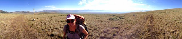
We followed them up the steep half mile climb to the side trail, and started off on our gamble. The first ~3mi were relatively straightforward, which I dutifully tracked on the GPS. We emerged into a beautifully open ridge which looked on to the pass, and we had amazing 360 degree views. The sun and wind were brutal though, and though we applied sunblock and were wearing hats, we still felt exposed. We walked to the nose of the ridge, and the GPS said to start bushwhacking down, at roughly 1 o' clock. We began our descent through the sagebrush, which wasn't too bad; a bit prickly, but with wide alleys between the brush to speed things up.

We suddenly noticed that there was a herd of brownish creatures at the bottom of the ridge, maybe ~50 altogether. A mother and child cantered away from the herd, and moved towards us. They stopped and stared curiously at us. They were much darker than deer, with long velvety ears--we guessed it was a large herd of elk. The elk shyly moved into the stand of pines just above them, and we could still see them watching us through the trees.

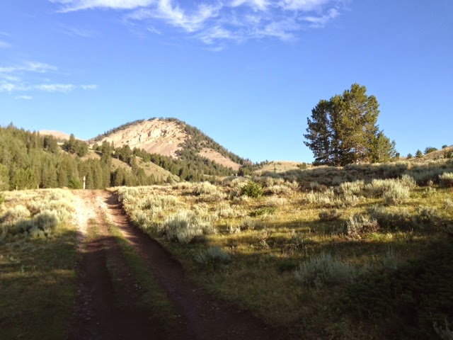
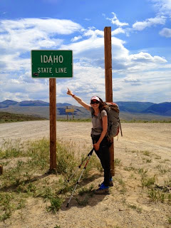
We continued down the hill, down to the creek, which we followed up to a jeep road. From the jeep road, we followed that to the dreaded gravel road (the only one in Idaho), which runs through Leadore. We had heard this was a terrible hitch, and were bracing ourselves for a long wait. Once we hit the road, we were below the pass, and had to climb steeply up 1.2mi to the pass proper. With ~0.8mi to go, we finally decided to take a break. Since we had left the water ~8mi ago, we had stopped for maybe a total of 15m. We were hiding under the shade of a tall pine on the side of a highway when a pick-up truck pulling a horse trailer approached. (Given the barren, dusty terrain, we could see approaching cars from literally miles away as a big yellow plume of dust). I braced myself for the dust bath, and hurriedly covered the protein bar I was eating to keep out the grit. The vehicle stopped just beside us, and I waved.

"Are you okay?" Hmm. I think we're okay. And then I realized, it does look like we're in dire straits. It's the height of the heat, and there are a pair of girls cowering under a pine tree on the side of a seldom travelled road. We assured them we were okay, and then made our way up to the pass. From the top of the pass, since we could see the cars from so far away, Gangles and I actually had time to debate hitching strategy. Hat on or off? Should I keep my hair in a ponytail or let it out?

Fortunately, we weren't up there long, when the second car, a Passat with an elderly couple (Lyle and Juva) stopped to pick us up. The gent said he wanted to get a good look at us, as he was particular about who gets in his car (as he should be!). As we were getting in, BR and Very Fit were approaching. I felt bad that we were leaving just as BR and VF were approaching, so I asked if he could take one more. He said emphatically, "I don't give rides to boys". Which is completely understandable, a big bearded guy getting in your backseat can be terrifying.

Lyle and Juva kindly gave us a lift to town. Thank you again for the ride--it was very much appreciated.

Town, finally.

We stopped for lunch at the Silver Dollar Diner, which had a new waitress in training, the 10-yr old granddaughter of the proprietor. She adorably and capably took our orders, and even gave us 7-Up from the temperamental soda machine, which kept getting stuck and flooding the area. We stopped drinking 7-Up and switched to root beer. We then checked in to the Leadore Inn, which very clean and nice. And no visible taxidermy, though the Silver Dollar Diner had quite a bit.

We are all in for the night, with Moosie, Bigfoot and SLAM! (the hiker formerly known as 'Trailbait'). Glad we're all safe together.

Mileage: 18mi from the spring past Gucci Polaski to Bannock Pass (Leadore)

Day 40 - zero

First off, thanks to all of the kind people who have sent us treats, including the McNabbs (cheeses, sausages and cookies shaped like terriers), Moosie's mom (trail mix and homemade granola), Wiffle Chicken (the best of Trader Joe's), and Sky Purdy's dad (brad bars, bacon cookies and a fertility fetish). Appreciate the wonderful generosity.

Today is an eventful day in sobohobo history--we lose Very Fit to real life. He's an educator, and has to be back for school, so the Swiss Fits took off today to make it to Lima, MT, en route to W. Yellowstone, then ATL. It was wonderful hiking with you. We'll all miss your wonderfully dry sense of humor, and natural hiking ability. Hope you have a great trip back, and re-entry into civilization, replete with a hair cut, oil change and quality BBQ.

The rest of us are enjoying our lazy day, letting our feet and legs heal, eating to the point of discomfort, and just lying around.

Back on the trail tomorrow.

Mileage: 0mi

Wednesday, July 24, 2013

Day 38 - Lemhi Pass

The countdown continues--we are only 40mi from the gravel road to Leadore! On day 5 in the backcountry, we're all feeling the need for a little R&R in town. The morning was one of the most mellow that we have had in a while, gently rolling ridge run on soft pine duff. Lots of confusing criss-crossing jeep trails, but we stayed the course. The trails today also crossed open meadows filled with blooming wildflowers, in white, yellow and purple, all mixed with seafoam green sagebrush. Pretty and fragrant.

At lunch, we reached Lemhi Pass, which is historic for being the place where Meriwether Lewis crossed the Continental Divide Trail for the first time. Upon summiting the ridge, supposedly he was astonished to see even more huge mountains to the West. Me too, Meriwether, me too. The mountains here feel huge. At the pass, we had a minor history lesson, reading all of the signs, and ran into two different Lewis and Clark expedition enthusiasts. A great yogi-ing then occurred. (FYI, a yogi is when someone gives you something, e.g., food, drink, ride, without direct prompting out of generosity). These kind people gave us several Diet Cokes, a cold root beer, and two bottles of Mike's Hard Lemonade. Which tastes like lemon soda to me, the teetotaler, but I only sipped. I didn't think I could walk if I had more than a taste. This prompted a very amusing revelation from Swiss that her go-to drink was once Zima, which really dated all of us who remembered that drink, and Gangles who is too young to remember it at all.

Lunched close to the pass at the Sacajawea Memorial picnic area, with the bombastically named 'Moste Distante Fountain', where Lewis and Clark were relieved to find water in such a dry area. We were as well. As with most once functional but now outdated things in the modern world, this once necessary spring was converted into a small decoration for tourists. Felt a little funny actually drinking from the spring, a throwback to more desperate days when you couldn't buy a 24-pack of water at Walmart. Like ducking under the velvet rope at a historic house to actually use the loom at Betsy Ross' house.

After Lemhi Pass, we made the major climb back up to the ridge to camp. While we were pitching tents, I saw a goldish bit of fur about 30' away. It was an arthritic fox, who was very curious about us. He slunk away, then came back, and sat, watching us. I'm sure he saw us all whispering and pointing. The wind kicked up, and I'm sure our scent was blown straight at him. He laid down, covering his nose with his ovoid tail, and continued to watch us. We snapped a few photographs, and then I started to worry that he was not running away. Just as I started to worry he had rabies, he rose to a sitting position, gave us one last look, and gamboled down the hill.

Also, had a chance to hike with Chinchilla and Pyrite today--great people. Chinchilla's brother is getting married this winter in MSP in the same venue as Gangles and I. Small world. So nice to see them, should see them in Leadore tomorrow, too.

Also, Gangles wrote a song about Montana. I hope she'll take the time to transcribe the lyrics here later. Keywords: hail, biscuits, Glacier, hail, wildflowers, hail

Mileage: 22mi from Eunice Creek Trail to Spring past the Gucci Polaski Spring (real name of spring!)

Day 37 - Hump day

Gangles left camp before I did today, and I finally caught up with her about 3mi down the trail. She was standing with bear spray clutched in both hands looking left with a thousand yard stare. Think vintage Charlie's Angels. Apparently, she had seen a misshapen black lump on the trail, which startled, then clumsily ran away, breaking sticks and trees in its wake. She thinks it was a small black bear, so bear encounter #2 on the trail. This one was shy as well, and ran away, so thanks for that.

Today was a very long day on the trail, over 27mi. When we planned this stretch, we knew we were being aggressive with the mileage, perhaps an expected consequence of planning late at night with beer. The sequence is supposed to be something like: 10, 22, 25, 27, 24, 16. The mileages are approximate, as each of the sources (Ley, Wolf, Bear Creek (Brown)) have slightly different counts. Today is the longest of the days, intentionally placed farther in when our packs are lighter, since we have less food.

It was a long 27, and we are exhausted. We are camped just shy of the Eunice Creek Trail, which leads to the only water in this section, downhill 450'. Very Fit, being the mensch that he is, graciously retrieved water for all of us. He is most definitely living up to his trail name.

The length of the day was tough on everyone, and Moosie and Bigfoot opted to stop at Goldstone Pass. Bearbait has caught up, and is down there as well. In camp with the Swiss Fits, BR and Grinder. We hope to see everyone tomorrow, or the next day in Leadore.

I tried to call the Leadore Inn today from a pass. The answering machine was great, since it is one machine for 1) Leadore Inn, 2) Lemhi Taxidermy, and 3) the couple who run both businesses. I'm looking forward to seeing the Inn. Assuming it is less Hitchcock's Psycho, and maybe more the Natural History Museum in DC with quality dioramas.

Also, it has been a dry section of trail. I bushwhacked down to a lake to pick up water. I did my best, but the lukewarm lake water was filled with tiny swimmers--maybe very small tadpoles or some kind of glacial lake shrimp. Gangles fished out all she could with our spoon, and we added an extra drop of bleach for good measure.

So relieved to have finished our hump day. 40mi more to Leadore over 2 days, which is very doable. The light at the end of the tunnel. Ok, off to study tomorrow's maps, and then bed.

Mileage: 27mi from Hamby Creek to Eunice Creek Trail

p.s., Barrel Roll and Grinder joined the Stangles' 30mi club today. Club requirements: Get lost and then found with a total mileage of 30+ mi. Bonus requirement: Find an abandoned cabin. BR and Grinder hit the bonus. Welcome to the club, boys!

p.p.s., Heard Jerry Brown was in the area today checking out new trail. Jerry Brown is the author of the Bear Creek maps, one of the 3 major data sources for the CDT. Celebrity sighting! Maybe I should tweet at TMZ to get credit for the scoop.

Monday, July 22, 2013

Day 36 - one more day down

Today was a lovely and scenic traipse past several lakes above 8000'. The waters were invariably clear, and either a deep blue or a slate grey, depending on depth. The terrain continued to be difficult, but rewarding with many views of majestic fins of rock.

We lunched next to a burbling brook in a field of wildflowers, part way up a long climb. We unveiled the Sprite, which seemed a nice end cap to a general lift in morale and spirits. Despite the brutality of this section, and the lingering and emerging injuries to feet, legs, etc. among the group members, we are making our way through this stretch. Tonight marks the halfway point with regards to days out--we have 2.5 more days to Leadore.

Our last 1000' climb was a long and tough one, but much improved from the maps, with longer switchbacks. Always fun to climb on fresh trail.

Tomorrow will be our longest in this section, a 27mi day, but the terrain is supposed to ease for the last 5mi. Unfortunately, this coincides with the last easy on trail water, so trading terrain difficulty for dryness.

I speak for everyone when I say we'll be relieved when tomorrow is over, and ecstatic to be in Leadore.

Mileage: ~24mi from the lake in the compass rose on MT 52 to Hamby Creek

Sunday, July 21, 2013

Day 35 - pep talks, state borders and wishing we were in Leadore

We are now 25% done with this stretch of trail to Bannock pass, and I wish it were sooner. I was telling Swiss today that if I could take a pill which would knock me out and miraculously revive me four days later, I would. This section is quite difficult with the steep trail up and down. Swiss actually gave me a pep talk, which was tremendously helpful. She highlighted that we have the Winds, the Tetons, Yellowstone and a good section of the Colorado Trail coming up. Gangles also helpfully pointed out that though this section is tough, we should have our trail legs by the end.

We left our beautiful camp this morning and hightailed it up a few steep climbs. We finally caught up with everyone at the first of the two passes today named 'Big Hole Pass', which is apparently a common name. Everyone seemed sluggish this morning, possibly a sign we should have taken a day off. But, there is no time like the present, so while I was wistfully thinking that my parallel universe self was playing mini golf in Sula, my current universe self was trudging down the CDT.

Gangles and I had just started to descend down from a ridge when we saw several horses tied to trees, without humans in sight. The CDT continued very steeply down a rocky looking jeep road. Had we not noticed the horses, we would have never noticed the brand spanking new trail just to our left. It looked as though it was just carved (for skiers, think fresh powder, it looked so good). This trail didn't appear on the Ley maps or on the GPS. So, leap of faith, we jumped on it. This had potentially terrible downside. The trail maintained altitude, while the jeep road (marked as CDT) descended sharply.

We took the gamble, and practically skipped down the new trail. There were foot prints, but we had no idea how long it would last. The danger with newly carved trail is that it could just stop, leaving us stranded on the side of the mountain. Fortunately, we started to see signs of recent humans, a couple of pickaxes lying against the mountain side. We came upon 3 people, sitting on the trail, eating a can of sliced peaches. This was the US Forest service crew who had been cutting the trail, which was started last year. We profusely thanked them for their hard work in improving the trail. I asked if they were native Montanans, and they told us we were in Idaho! I knew we skimmed the border, but didn't realize that we were on the Idaho side at the moment. They said they had tied one of the horses in Montana, and the rest in Idaho. Maybe this was a political statement? Anyway, they mentioned we were lucky we were here today, since the trail would be closed tomorrow--they were going to dynamite the tree stumps on the new trail. We had noticed that the tree stumps had small holes dug around each one, maybe the circumference of a can of soda. I imagined it cartoonishly, each tree stump festively surrounded with a red stick of dynamite reading 'ACME'. Also, heard some exciting news that Train, Swallow and Stag had been through a few days earlier. Maybe we'll see a few more thruhikers in Leadore. Thanks again to the trail crew for all of their terrific work, and for getting the latest news.

We continued down to Bradley Gulch, where the trail was not finished, and we essentially bushwhacked the last 0.25mi, following flags tied to trees, and fresh blazes. The CDT became quite confusing after this. Ley mentions on the map that we should stay generally left, but that the trails are not clear. We did come across a cabin, which I wanted to explore, but Gangles counseled against it, making the relevant point that we are still relatively close to where the Unabomber's cabin was found. The Swiss Fits did check it out, and apparently, it was an old prospector cabin filled with random detritus.

We pushed on, and started the long climb of the day, over 2000' in total. When we finally crested the pass a few hours later, we were much relieved. The pass had loomed in front of us for the entire climb, both visually arresting and heart stopping in steepness. The photo is from the top of the pass, where Gangles passed me one of our rationed snacks for the day.

We were wiped out, both physically and emotionally, and on a strict stop for breaks every hour. We finally dragged ourselves into camp, which was absurdly buggy. I couldn't use my hiking poles for the last 2mi, I was too busy wiping mosquitoes off my sleeves. They were descending in bunches, several at a time on each shoulder. I had a special rotation, wipe the left sleeve, right sleeve, and head to clear each area. I imagine I looked like a giant housefly, rubbing my hands together. And all the while, that horrible tormenting whine of mosquito wings in my ears. I may have to relent and apply the DEET I've been carrying, but avoiding because it is so poisonous.

We all finally got into camp, and I built a very small fire circle, digging it out and encircling it with rocks. The smoke helped a bit with the mosquitoes, but the morning will be tough. Tomorrow should be fun, if arduous. I've been told we are in one of the most remote parts on the continental U.S.--there are no roads within 25mi at the deepest point. I was shocked to learn this, and how much infrastructure there is in this country. A true backwoods experience, so I'll savor it. On the plus side, tomorrow is supposed to be quite scenic, even as we have another long day (~25mi) planned.

Oh, I have a small secret. I can tell you since the other sobohobos won't see this until I post it in town anyway--I'm carrying a Sprite. This may not seem like a big deal. But let me explain. Out here, for whatever reason, we all seem to crave soda. Full sugar, ice cold soda. And we don't carry it because it is heavy. A bottle of Sprite is 20oz. To put that in perspective, a full day's worth of food is ~2lb (32oz), so to bring 20oz out on a long, tough stretch and save it for a few days in is a real luxury. I keep meaning to bring it out to share, but we've had other special moments. Yesterday, Grinder thoughtfully packed out a can of Coke, which we all passed around. And today, Grinder, Bigfoot and BR were given 2 cans of beer by some strangers. So, maybe tomorrow, on a long day, we can all share a Sprite and lift our spirits.

Mileage: ~21mi from Nez Perce camp to small unnamed lake in compass rose on Ley map MT 50

Day 34 - I would walk 500mi?

Big news today, I think we crossed the 500mi marker. We were at ~490 at Chief Joseph Pass, and hiked out ~10mi today. The mileages are hard to figure out on this trail, since the trail is not completed, and there are so many alternate routes. We should be 15-20% complete with the trail at this point.

And not soon enough, since this next section is a real doozy. I think I mentioned that we have ~125 to Leadore (apparently this is a compound word, and pronounced 'lead' 'ore', in reference to mining, which seems to be a major part of the economy). This is supposed to be the toughest hitch on the trail, ~30mi on a gravel road. The terrain is supposed to be rugged as well.

Today, we had a nearo, so hiked 10mi. To start, this section certainly lived up to the hype. There appear to be no switchbacks, just steep climbs up and down. As a wise man once told me on the AT, the uphills are tough, but the downhills will kill you. The trail is pressed flush against sheer hillsides, and a spaced out footstep, vertigo or even a loose rock could be a long tumble.

Our first 8mi out were fairly uneventful, some tough climbs up and down a jeep road. We came to a fire notice, since much of the next 10mi had burned this time last year. This is not surprising, given that nearly 40% of the pine trees are festooned with bright orange pine needles, indicating death and extreme flammability. Bigfoot resourcefully used his phone to discover that the burn notice had been rescinded, and we pressed on. From our vantage point, we could see the large burned patches of trees, silvery on the hillside. Glad we were climbing in the evening, so the sun was lower.

We made camp at the Nez Perce campsite, which is supposed to be one of the nicest in this section. The spring downhill 0.1mi was absurdly beautiful, with a tiny pool created with carefully stacked rocks, and magenta wildflowers.

Though we all could have used a day off in town, the beauty of the sunset at camp made me glad we were on the trail. I love watching sunsets from saddles, where you can see the whole color gradient from midnight blue to orange filtered through tall sere pines. Lovely.

So, feeling a little anxious about this upcoming section, but will be so glad when we have it behind us.

p.s., Fond thoughts to Bearbait, who we left in Sula to recover from her foot injuries. Hope you're recuperating, and that we cross paths again.

p.p.s., Sula is a great town stop. The folks couldn't be kinder or more welcoming. Thanks Richard and Ed for the lift back up to the trailhead. Feel like real pioneers on the Lewis and Clark route.

Mileage: ~10mi from Lost Trail Pass to Nez Perce campsite

Friday, July 19, 2013

Day 32

We woke up this morning with blessedly clear weather--blue skies and a bouquet of a dozen red roses from Montana. It's as though nothing, certainly not a torrent of thunderhail, happened yesterday, We knew we had a big day to make up, so we had an early morning, with a big climb up to Pintler Pass. The climb was arduous, but the view of the past few miles was spectacular. As I waited under a pine tree for Gangles at the top of the pass, I heard a soft, repetitive "THRUB THRUB THRUB", and we saw a spectacular omen: a tiny green hummingbird darting around.

Gangles and I continued our comedy of errors, and did take the wrong trail steeply up the hill about 100', but we quickly realized our mistake. I was still optimistic because of the good omen of the hummingbird.

They day was tough, rolling up and down the divide. The toughest part was losing the trail on a rocky white peak, where we bushwhacked for a while. We booted up the GPS which led us back to the trail. At the top of the pass, I surprisingly got cell reception, and actually talked to my sister for a few. I felt so much more human after that.

When we rolled down the hill, we ran into Barrel Roll, the Swiss Fits, Grinder and Bigfoot. We hiked to the last water for the day, and cameled up. Between us, Gangles and I carried 7L back up to the divide where we made dry camp on a beautiful saddle. Moosie didn't come in; she decided to stop short a mile, but sent us a text message saying she'd see us tomorrow. So, we were not worried.

Going to bed, with the vestibules open. Counting on nice weather tonight. THe moon is quite bright, almost too bright, but just so glad to be in. Sula tomorrow night.

p.s., Day 32 reminds me of that great TLC song, 'Creep', where they talk about the 32nd of loneliness. Also, 2^5!

Mileage: 25-28mi (?) from Johnson lake to a few miles shy of Schulze Saddle.

Day 33 - Sula!

I'm writing from a cabin in Sula. We started this morning a few miles shy of Schulze Saddle, for a 23mi day in to Lost Trail Pass.

After a long day yesterday, when we were finally in our tents, we heard some scurrying yesterday. It was Little Bug and Aaron, giggling as they ran by. Apparently, they were attempting 30mi on their 30th day on the trail. The moon is waxing, and it was a bright night, so hope they had a good night hike.

We started off early today, knowing that we had somewhere between 21-23mi today, with a hitch to Sula to get in before the store closed by 6pm. Gangles and I left camp early for us, by 6:45am, and were nearly the last ones out. Even the Swiss Fits beat us out. This was accompanied by the comic sight of Very Fit pulling down the tent with Swiss Miss still inside.

I was a little delirious and sleep deprived by the early departure. About a mile after camp, I ran into a tan scrawny, naked man peering shyly at me from the trees. Great, just what I need--a naked hillbilly at 7am. I finally realized that the naked man was actually a deer, staring at me straight on, and I mistook the front legs for skinny legs on a man. The deer finally realized that I was a person, and took off down the hill.

The rest of the day was beautiful, rolling up and down the ridge. We re-entered a burn area, which made it hot, but gave clear lines of sight throughout the day. We were down to the pass by 4:30pm, which is great timing. Bigfoot, Swiss Fits and Gangles caught the first hitch out while Barrel Roll and I went up to the Visitor Center. No luck there, so BR and I went back down to the pass, where we met Grinder.

An older man with long grey braids and rainbow suspenders picked us up in his RV. He was headed for a Rainbow Gathering, and let us ride in the back on the way to Sula. His RV was a cozy little camper, with cribbage boards and wood burning stove. We were so excited when we finally arrived, and in a tizzy bought every frozen pizza in the store for dinner.

Also, ran into Chinchilla and Pyrite, who we overlapped with for a hitch to Elliston. Funny, small world, Chinchilla is from Minnetonka! Home of Prince, and pretty much where Gangles grew up. Chinchilla to Wayzata HS, which is where Gangles' cousins went to HS. Really a nice coincidence. Also, they told us that we are such a mob on the trail that we are known as 'The Nine'. Which I know can sound rowdy, but we really are nice people.

We're all safely ensconced in a cabin, planning for the next stretch. This one is going to be hard. It's a 122mi stretch with more elevation gain and loss than we've faced to date.

p.s., When ordering food for delivery to Sula, I considered adding a copy of the novel by Toni Morrison. I remember really enjoying the book back in the day.

Mileage: ~21-25mi from a few miles shy of Schulze Saddle to Lost Trail Pass

Wednesday, July 17, 2013

Day 31: The Thunderhail edition. (aka the "Mommy!" edition)

Gangles asked me today if Montana is called 'Big Sky' because the it just opens up. This afternoon, as we were climbing up to Rainbow Lake (~8500'), the weather went from blue skies to thunderhail in less than 10m. The skies progressively darkened, then began to drizzle. No problem, I thought, this will probably blow over quickly. But instead, the weather worsened.

The drizzle compounded into real rain, accompanied by lightning and thunder. Then the hail, the size of quarters, came pelting down, and I hid under a tree to avoid the hardest hitting parts. The trail transformed into a trough of what appeared to be my sister Gloria's favorite, Italian Wedding soup. The hail coursed downhill with the rain, racing by. Gangles caught up, and we debated pitching a tent right then and there, since there was no sign of blue skies.

We also debated the wisdom of continuing to follow the trail, which climbed steadily to a pass above treeline. We agreed to follow the trail, and reassess before we hit the open ridge. Luckily, we ran into the Swiss Fits, and somehow it was less scary with all four of us together. The skies brightened, and I was optimistic that the storm would be over soon. We kept marching along, a rain suited foursome, until the skies cleared again, as though nothing had happened. Blue skies, with the odd fluffy, happy cloud. As quickly as it had started, it was over.

Relieved, we hustled down to the lake, and found Bigfoot, Barrel Roll and Grinder already tented, which was a relief, since we had discussed going on. While the weather had cleared, and we could have hiked on, we were all a little emotionally traumatized by the brutal weather.

Despite the precipitation, this section of the trail has been wonderfully scenic, like a smaller Sierras. We've been walking pass to pass, traversing stark bowls with granite and glacial lakes. Along with all of the Glacier and the Chinese Wall, I'd describe this as a highlight to date.

The trail is well-manicured here, clear and neatly marked, with signs for every major pass and lake. Relatively easy to follow, and on nice pine duff for the most part. There are short stretches on piles of loose shale, which feels uncomfortably like walking on broken dishes. I always imagine myself in a Tom and Jerry cartoon as I'm slipping around on the rock fragments.

And, I love the animals here. We've seen plenty of deer, but I have a real soft spot for chipmunks. Maybe it was years of watching "Chip n' Dale Rescue Rangers" as a kid. Or their pert little scampers. Or their great eye markings, like little glam rockers. They really liven up the area.

So glad we're all in, dry and safe. Think we have a big day tomorrow. We're looking at 28mi. It's hard to know for sure, since every source (Bear Creek, J. Ley, and Wolf) have slight differences of opinion. While a 5mi discrepancy may not seem like much, it does make a huge difference when we've got such small margins of error when trying to dodge weather, climb passes and hitch into town.

Another beautiful and brutal day on the CDT.

Mileage: 21-24mi from Flowers Lake to Johnson Lake

Tuesday, July 16, 2013

Day 30 - Into the scenic wild

After spending a leisurely morning at the Springhill campground, the Swiss Fits, Gangles and I decided to take the alternate up the Storm Lake Creek road up to Storm Lake. The road was nicely graded, and after a few hours, we climbed up to the lake, which was lovely. J. Ley marks the road as 'well-travelled' and a 'popular trailhead'. We saw 6 cars on the walk up, and people couldn't have been more friendly.

One pick-up truck stopped and asked where we were headed. After replying 'Storm Lake', he said 'hop in!'. We declined, to maintain the purity of our continuous footpath from Canada. We later saw him at the lake, with his grandchildren, enjoying a picnic.

After the lake, we climbed up to Storm Lake Pass, which had stunning 360 degree views. We could see Goat Flats to the South, and the CDT continuing. (See photo). This is supposed to be a beautiful section of trail, and we are very much looking forward to the rest of the journey.

Just after we pitched tents and started cooking dinner, the clouds came rolling in from all directions. We ate hurriedly and dove in to our tents. As the drizzle intensified, Barrel Roll comically (and quite practically) enveloped himself in his poncho as a mini-personal tent. He drew into himself, like a turtle in a shell, and was somehow able to finish cooking and eating while hiding under his poncho. It was a remarkable display of ingenuity and economy of motion.

Since then, Gangles and I have been napping and reading all evening. I'm glad everyone is in, warm and dry. We've all been socked away in our sleeping bags, chatting from tent to tent. The camaraderie of the group is a huge positive, even in light of terrible weather.

Oh, and we are wrapping up our first month on the trail! Good times.

Mileage: ~15mi from Springhill campground to Flower Lake

Day 29 - Leaving Anaconda

Another beautiful day in Anaconda. Really a lovely small town. Sad to see Hiccups go, he successfully hitched to Helena in the afternoon, and picked up his car. A great companion for this stretch, hope he enjoyed his time out on the CDT.

As Gangles and I were waiting for packages to come in, the Sobohobos decided to make today a nearo. We would aim for a campground ~12mi out of town, so we could spend most of the day in town wrapping up errands.

Gangles and I had ordered a few things from Amazon, and spent the morning running them down. Apparently, for our items, they were broken up into 3 different carriers: UPS, USPS and FedEX. At the outskirts of town, I saw the UPS truck, and ran up. After chatting with the driver, I convinced him to give me my package on the spot. It was both convenient and somewhat worrying that I was able to do that without ID. The other two packages proved more elusive.

We tracked the FedEX package down at the Marcus Daly hotel, which was run by a very sweet woman named Fay. She's been in Anaconda for 35+ years, and loves the area. We had planned on staying at her hotel, but they were booked up, since one of the largest softball tournaments in the country was in town for the weekend. And Monday night, there was a major U.S. Amateur golf tournament being held at the local Jack Nicklaus designed course. He filled the sand traps with black sand, which comes from the slag leftover from the local copper mining.

The final packages was supposed to be at the post office, but the letter carrier had some miscommunication, and had taken off with it. It should be forwarded to Sula, where we will arrive on Friday. Fingers crossed.

Apparently, Sula is a very small town. It's so small that when mentioning it to locals in Anaconda, most people respond with "You mean 'Missoula'?". I looked Sula up on wikipedia: population 37, area 3 sq mi. By arriving in Sula en masse, we will be vaulting the population up into the 40s. We also hear alluring rumors that there may be a Conoco, which means a cold soda to us. Very exciting. (Have to celebrate the small joys in life).

After leaving the PO, we went to the next rally point in town, the local Dairy Queen. This was a Dairy Queen Brazier, the complete package, serving both hot and cold foods. Of course, we hoboed the place up, loitering in the corner of the courtyard, eating tremendous quantities of food and finalizing our packs to leave town for the next stretch. I swapped out my disintegrating pack for the new version I picked up in town. I walked to the nearby dumpster to dispose of the box and the pack, feeling like a true 10 on the hobo scale--rummaging around in trash near a fast food restaurant.

On the way back to the Dairy Queen, I was waylaid by a woman in a purple hat, wearing a red shirt. She was one of a gaggle of similarly dressed women who were in a different corner of the DQ courtyard, each nibbling on a Strawberry Cheesequake. She said she had been chatting with one of my companions, and heard about our trip. She wished us luck, and hoped we would enjoy our time in her home state of Colorado. She spontaneously hugged me, which I hope was okay for her. On the plus side, I had showered and laundered my clothes. On the downside, I was just rummaging in a dumpster. She then got in her car, and drove off.

I keep saying it, but I'll say it again--people here are exceptionally nice. While very few people seem to know what the CDT is (which is a departure from my AT and PCT experiences), most people are so friendly and interested in our trip. I really feel as though I'm in the Midwest: unaffected niceness, and the common colloquial use of the phrase "you betcha!". Montana really is a great place.

Mileage: 12mi from Anaconda (East end of town) to Springhill campground

Monday, July 15, 2013

Day 28 - Outskirts of town

Big news on the trail front! Dave has finally acquired a trail name. (Floggings to any who call him 'Dave'). His self-explanatory trail name is 'Hiccups'. Sad to be losing him here in Anaconda, but so glad that he was able to experience the sampler platter of the CDT: fair and inclement weather, wildlife sightings, trail and road walking, climbing up scary sounding mountain passes (Thunderbolt!). He's made some noises about meeting us in New Mexico with KK, which would be great.

Today, we had 23mi to get to Anacconda. We had initially planned on stopping at Uncle Buck's in Warm Springs, but it is closed on Sundays. The fast and tough part of today is that the trail is almost entirely road walking, either on forest service road, or along a frontage road to a highway. So, fast because the terrain is smooth and graded. Tough because the repetitive terrain causes overuse injuries, generally lacks tree cover, and because I don't want to get hit by a car.

The long snaking dirt road out of camp felt like a country road, and I found myself humming that John Denver song. And imagining myself as one of the Dukes of Hazzard, straightening the curves as the road gently undulated around the hills.

As we exited the forest, we emerged onto a working farm. Grinder and I were walking together, and we (mostly me) were baa-ing at the talkative sheep. Apparently, my sheep is rusty, and they skittered away as we drew near. A dark blue pick-up truck came around the corner, and Grinder and I moved over to the shoulder. The truck slowed as it approached, and the passenger door popped open. A tow-headed blonde boy, riding with his younger brother and his father, asked us how we were doing, and offered us water. We were fine on water, and they all wished us a good trip. Such decent, hospitable people in Montana--feels like Midwest niceness in mountain scenery, really a nice blend.

Grinder and I caught up with the pack of the Sobohobos down the road, and I realized that my phone worked. We were close enough to civilization that my phone worked. Goodbye GPS and J. Ley maps, I navigated us to Anaconda using Google Maps on my phone. A first on the CDT so far.

During the next 5mi stretch, we ran into two other local Montanans, one a farmer who moved from St. Louis 30 yrs ago, and an older gent on a vintage BMW motorcycle going for a ride. Both were friendly and chatty, and offered us water. Small town hospitality.

We made it to Buck's for lunch, and sat in the shade of nearby trees to eat the last of our camp food for this stretch. We learned with great and weary excitement that the nearest gas station was a mere 8.2 mi away. We set on down the frontage road with dreams of soda in our heads. One of the strange things about thruhiking is that we crave things we never consume in regular life, and we are overwhelmed with cravings for junk food. Soda, ice cream, chips, fried foods. Our bodies crave and need the sugar, salt, fat.

While I would never daydream of loitering in front of gas stations in regular life, doing so is a veritable fantasy (see photo for quality hobo-ing). We decided to do a restaurant crawl and wait for everyone to come in. And hit the local Chinese place for dinner--nice to eat something other than a hamburger. Glad we're all in town, and in good spirits.

Resupply, waiting for packages, and then headed out late tomorrow.

Mileage: ~23mi from non-existent ranger station past Four Corners, to Anaconda

Sunday, July 14, 2013

Day 25 - teacup time!

On this side of Macdonald Pass, the terrain has subtly shifted from rollercoasters, to the teacup ride. As Grinder describes it, we're on 'microterrain', with regular ups and downs of 30'-100'. The rollercoaster had ups and downs an order of magnitude higher (300'-1,000'), and so today's hiking has simply been more humane.

We had a slow start today, a nearo out of Helena. Barrel Roll's friend, Dave, is out here to hike for a few days, and he was kindly shuttling us to and from the trail. Since Gangles and I were in the second shift, we had some time to run a few extra errands.

First, we finally got her a hat for sun protection from the local craft store (i.e., an independently owned Michael's). We asked the clerk if she had hats, and she asked if we wanted adult hats. Intrigued by her response, we followed her to the kid's hat section, where the hats were really foam visors for elementary school arts and crafts projects. The ultimate choice was between a giraffe print, or a blue sparkly visor. I thought the giraffe would be more LNT (leave no trace), since I was imagining a trail of sparkles from here to Anaconda. But, hard to argue with fashion, and she went with the blue sparkles, and I must say, it really ties her hiking outfit together.

Second, had a terrific breakfast at the No Sweat Cafe--always so good to eat fresh cooked vegetables. The cabbage and green onions on the scrambled eggs sustained us during the great day of hiking.

Always rejuvenated after a town day, we all felt plenty energetic as we set out around 3pm this afternoon. The weather was Montana-fickle, transitioning from blue skies to that strange colorless shade that accompanies the drizzle. We got to camp just as the rain started to fall. We pitched hurriedly, and dove in. Both Gangles and I famously hate the rain, probably still having flashbacks from the Oregon and Washington sections of the PCT. Swiss Miss, Grinder and Bear Bait all soothingly talked us out of the tents to cook dinner, telling us the rain was light. The rain was intermittent, and clear enough for us to venture out. As the rain let up, we did see a brilliantly orange sunset, which did make it seem all worthwhile.

Now, regarding the rain, I do remember loving the rain as a child. I grew up in Virginia, and the hours before it would rain in the summer, the air would be palpably thick, something you could cut with your hands straightened into blades. Rain would come as a relief to all of that tension, thickness. And it was usually a warm rain in the summers, a benign thunderstorm. I loved summer rain so much that I kept an extra large set of clothes in my school locker. Whenever it started to rain, I would excuse myself as though I were going to the restroom, but actually beeline to my locker. I would suit up in my extra large clothes, run around in the rain, and then slip back into class after shedding my damp rain clothes.

Montana is almost making me love the rain again--while some of the precipitation is terrifying (marble-sized hail, damaging winds), I am enjoying the temperate afternoon drizzle, which disappears so quickly. I certainly hope the weather holds.

Oh, and forgot to mention--Dave is in sore need of a trail name. As a group, we're working on something, so will keep you posted on the progress. He's in great shape, and usually leading the pack while hiking--we thruhikers need to hustle to keep up. Glad he's with us to Anaconda.

Mileage: 11mi from Macdonald Pass to Jericho Creek

p.s., Macdonald Pass has a tragic history. Constant Guyot, a frenchman from the 1800s, ran a toll road here. His wife was renowned for her hospitality and hearty meals. She was found brutally murdered one day, and rumor has it that she haunts the area. Constant Guyot was suspected, as he fled the territory shortly thereafter. Also, famed aviator Cromwell Dixon crashed nearby the pass, two days after being the first man to fly across the Continental Divide. Fingers crossed that those tragic events are in the past, and we are due a returns to the mean. Should be a good stretch.

Day 27 - Anaconda time

Today, we split off the official CDT to take the Anaconda route. Before I go into what that is, I'll give you a moment to speculate wildly. To jog your thoughts: ANACONDA.

I'm sure some of you thought of the J. Lo movie (which an anthropologist buddy of mine told me is the highest grossest movie of all time in Papua New Guinea, which has an aboriginal snake origin myth), or Sir Mix-a-Lot. Gangles has been singing that song a lot today.

The Anaconda route veers south towards Anaconda, MT, which is famous on the CDT for having what is rumored to be a full-service, Dairy Queen Brazier (i.e., with tater tots and Texas Toast). Gangles and I are reaching the end of our food bag, and have at least 3 days worth of protein bars left, but little other food. A walk into a larger town with less-protein-y food sounds great.

The hiking today was lovely, a mixture of meadows, rolling green hills and dirt forest service roads. We've been hiking together in large clumps, and today has really felt like it has been about trail family. Before beginning the CDT, we had all heard so much talk about how this trail is unlike the AT and PCT with regards to seeing other hikers. We are truly in a bubble--some folks ahead and behind, but roughly equidistant, and we go days without seeing other thruhikers.

We are camped tonight at the site of a former ranger station, which has been torn down. We are by a pleasantly burbling creek, and the skies are totally clear. Really a nice day, being with the other sobohobos, and enjoying the day's walking.

Tomorrow, we head into Anaconda, or Uncle Buck's. Since we are on the alternate, there is no mileage, and it is unclear exactly how far away we are.

p.s., Thanks to Maron and Sandy for the new socks and rice krispy treats, both of which have been fueling this hike.


Mileage: ~22mi from Cottonwood Lake to ~5mi past Four Corners

Day 26 - this hike brought to you by honey, and the letter B

First off, thanks to the McNabbs, who managed so considerately to send 2 lb of baklava to Montana from Zurich.

At our first break this morning, Gangles and I pulled out the remaining pound of baklava, and polished it off. At 240 calories per serving, and 8 servings, the entire package had ~2,000 calories. Now the RDA for calories for a woman of my size and age is probably between 1,500-2,100 depending on my activity level and weight maintenance goals.

Gangles likes baklava, but I *love* baklava. I have a problem with honey--I used to keep a honey bear in my desk at work. In my worst moments, I've been known to nurse on a bottle honey while lying on the couch. I usually stop because my throat hurts from the sweetness. And in case my dentist (Dr. V) is reading this, I do brush 2x per day, so don't worry.

In any case, baklava is just about solid honey. And I think I ate 75% of the baklava, plus some assorted other snacks for a total caloric intake of ~1,500 calories in less than an hour. Just as the food coma was setting in, we tackled the next uphill, and I did feel logy. However, the rest of the day, I felt great! Instead of needing to snack every 2-3 hours to maintain energy, I was sustained for several straight hours with my baby camel's hump of pure baklava. So, thanks to the McNabbs for powering today's hike.

As we were hiking along in the afternoon, Gangles and I spied a few spindly brown legs along the trail. Too spindly to be bears, fortunately. As we debated what to do, the spindly legs, attached to 4 female elk, heard us, and tore off into the brush. Fun to see wildlife, but a reminder that we should be making enough noise to scare away bears, and see no wildlife at all.

Gangles and I took the alternate today, bypassing Thunderbolt Mountain, and we arrived at camp early. We pitched our tent, and then I dug out a fresh a small divot in the ground, and surrounded it for a small fire. The bugs are quite aggressive, mostly mosquitoes, but a few biting flies. Everyone got it well before sundown, and we had a terrific meal together around the fire. Great night.

Mileage: ~18mi from Jericho Creek to Cottonwood Lakes

Wednesday, July 10, 2013

Day 24 - Helena (the Capital!) and Elliston, MT

I suppose many of you may wonder, if we've gone off to live in the woods, why do we spend so much time talking about civilization? Being in the backcountry makes me fully appreciative of the pleasures and comforts of town: indoor heating / cooling, running potable water, electricity, access to loved ones. So, today was a real treat, picking up mail in Elliston, and a trip to the capital.

We had initially planned to stay in Elliston, but the local motel has 4 rooms. Travelling in a trail family of 9, we were unable to get in, since it was booked solid through mid-July. We decided to pick up mail, and then hitch out to Helena. Since Gangles and I look harmless (and I emphasize, are harmless), we've had generally good luck with hitching. We volunteered to take everyone's driver's licenses down to Elliston to get the mail.

After 15m or so, we got a fortuitous hitch from Mike Reider, who was on his way to Missoula. His family has been in MT since the mid-1800s, first coming out to mine, then making their name and fortune by supplying miners. Better to supply the dreamers, than chase the wisps of a mining dream? His family has a gulch named after him, and looking forward to seeing it when we get there tomorrow.

By picking up mail for 7 people, we did significantly declutter the PO. The postmaster mentioned that he was wondering when we would come through--our boxes filled a corner of the small PO. Just as Gangles and I were despairing of how we could get all the mail back, a part-time PO employee offered us a ride to Helena. We texted the rest of the Sobohobos and told them that we were fine transporting the boxes, and to meet us in Helena.

By the time we were crossing back to Macdonald Pass, we still saw the Sobohobos out there hitching. Of course, they had elected to use Swiss as the frontwoman, and hide the boys in the bushes. Swiss is a former D-1 basketball player, with long blonde hair, and hence, an excellent hitcher. Since it is often easier for a woman to hitch, we stash the boys in the bushes, and if someone pulls over, we ask if we can take a few more with us. This may sound deceiving--it is. But it is merely practical. Would you pick up 5 large bearded men with ice axes on the side of the road?

We were able to squeeze nearly everyone into the truck, and we were off on our merry way to Helena, MT. We stopped off at the Lamplighter Inn, which gets great reviews in Yogi's. Joe, the owner, like Barrel Roll, is a UNH grad, and treated us kindly. Turns out, Joe and I share a previous employer, both spent time in the DC-area. He's also a Columbia MBA--nice to meet another MBA on the trail. He's since given up the rat race to be a musician and entrepreneur in Helena. Pretty enviable life. And funny how little things work out.

At the laundromat, getting clean, and then maybe hitting a Chinese buffet and movie later? I almost feel like a citizen of the real world, and not a forest creature burrowing in a pile of dirt.

And, Barrel Roll's friend Dave will be joining us tonight. Looking forward!

Oh, and a shout out to Maron and Sandy for sending such a great care package of Cheez-its, Rice Krispy Treats, and socks! Thank you! You are both rock stars, and your wonderful food will warm our hearts. And power us up some mountain next week.

Mileage: Big, fat zero walking. Some hitchhiking from Macdonald Pass to Elliston to Helena.

Day 23 - Sumo and Dixie visit, and trail magic happens

Another beautiful morning on the CDT. You know why? Because we got off the rollercoaster! This may be a temporary reprieve, but we spent the first 10mi of the day, walking down forest service roads, which are practically a vacation compared to the ups and downs we've been trudging up and sliding down.

We are most definitely in cattle country, walking through lush green valleys, surrounded by herds of cattle. Some short coated and black (Black Angus?), and some shaggy red and white (Hereford?). I know that the idea of a cow is usually a benign one--but they strike fear in my hearts. Maybe it's because they weigh a ton (a literal ton or half ton), or because they are skittish and unpredictable. Or because they heard me joking about their children as "schnitzel on legs", and glared at me while urinating. There is something most definitely unnerving about walking through a field and having 30 sets of eyes follow you, and knowing those sets of eyes are attached to large, swift creatures.

These large, swift creatures also eat like large creatures, and the trails and fields are spattered with hubcap-sized cowpies. We carefully pick our way through them, but some of those evil bacteria (giardia, crypto, etc.) in them must be making their way into the water. We are treating our water with Clorox bleach (2 drops per liter + 30m), which turns our water into the swimming pool at the local YMCA, but we are still ambulatory, so it must be working. In case you are worried that this is *not* good for us, Swiss Miss' father did call the Clorox 1-800 consumer hotline, and they confirmed this was a-ok.

Wayfinding has continued to be challenging. Gangles and I are convinced we have some bad, chaotic ju-ju attached to us, so followed the Swissfits and Bear Bait to Macdonald Pass today. This was a battle for the ages--their general competence and GPS devices vs. our stochastic force for being misplaced.

I'll call this one a draw. We did get to Macdonald pass without tears, but we did get lost a few times. We walked by some decaying railroad trestles, built up ~20', and then lost our way on a well-used game trail. Eerily, someone had tacked a deer skull on one of the trees, which we should have seen as a harbinger of chaos and being lost, but we merely interpreted as unusual home decor.

We drifted farther and farther off the CDT, and had to bushwhack back east, including a shady slither under a barbed wire fence, and wading through navel-deep grasses. On the plus side, this did prompt a fascinating history lesson from Swiss (PhD candidate in American History) on the history of the American cowboy, and the effect of barbed wire and refrigerated box cars on cattle drives in the late 1900s. I am honored and edified by travelling in such learned and sophisticated company.

We finally found our way back to the CDT, made it up Priest Pass with another minor bushwhacking incident (CDT: 2, sobohobos: 0), and down to the Macdonald Pass. There, we were greeted by Sumo (AT '06), and old friend of Swiss', and his lovely Australian Shephard named Dixie. Dixie is a real looker, a red and white mural with a beautiful fluffy coat and two different colored eyes (blue and brown, like Kate Bosworth). She has lovely Southern manners and deeply bred herding instincts, so kept us tightly clustered and safe all night.

Sumo had so thoughtfully prepared some trail magic for us, with a veritable hiking feast: pizza, cookies, chips, chocolate, milk, wine and beer. And better yet, we had a chance to swap stories about thruhiking, and hear about life in Montana, aboard a fishing vessel in Alaska, and desert hiking. Sumo, you're the best--thanks for coming out to meet us.

Mileage: 19mi from Dana Springs to Macdonald Pass

p.s., Montanans seem very friendly! As we were walking along Hwy 12, we had several friendly honks, thumbs up, and peace signs flashed at us

Monday, July 8, 2013

Day 22 - get me off this thing

What a wild and crazy day.

"STEIN! STEIN!" Gangles was yelling for me as I sauntered back from my morning privy. In the few minutes I was gone from camp, the skies had gone from clear blue to Mt. Doom ominous. We put on our packs and dashed south. We made it maybe a mile when we were socked with a thunderstorm. We had just secured our ponchos, when 10m later, the storm was over, and we were back to blue skies.

The weather here is wildly temperamental, sometimes home on the range quality blue skies, and then sometimes, these flash storms. Later in the afternoon, we saw storms behind us (North), and to the right (West), and both were closing fast. Paradoxically, we could hear thunder, see rain (grey smudges running from the clouds), and at the same time, we could see the blue skies behind both. Gangles and I hiked on, then the skies darkened in a trice, and we hurriedly threw on our ponchos. Hailstones the size of marbles mixed with pelting rain overran us for ~45s, and then it was blue skies again. Like nothing happened, like an "I love you, take me back, I'm yours, Montana" mash note. My genius plan to wait out the rain was to hide in the unattended CAT tractor on the side of the trail, but Gangles vetoed that for many sensible reasons. Mostly for the felony grand theft auto reason.

Oh, and the other excitement of the day. Gangles and I got "misplaced" again. We followed the trail up a grassy knoll, and the tracks disappeared. This time, the GPS was our undoing. The GPS marked us as off the trail, and noted the trail was due east a quarter mile. We bushwhacked though the meadow, and down the side of the hill, which descended steeply. Standing on the side of the hill, with my boots dug in sharply, the GPS indicated that I was standing on the trail. Gangles and I wove up and down the trail, crossing it at least 6 times by the GPS' reckoning, but there was clearly no trail. The GPS had the old CDT programmed in, which no longer exists. There were tears, but only 25-45s, since we are now old hands at being lost on the CDT.

We did chance upon the ruins of a cabin, which was eerie since the Unabomber's cabin is rumored to be in this area. We finally backtracked, an found ourselves in a different part of the meadow. We headed due south and ran into the other sobohobos. They had just gathered water down a side trail. They were just leaving lunch, and we were determined not to be left behind, so ran off with them, foolhardily starting a 14mi waterless sections with only 1.5 liters of water each.

As expected. we were terribly thirsty during the remaining 14mi, carefully rationing what we did have left. We had over 2000' of climbing, so it was an uncomfortable last stretch. We finally ran out with 5mi to go. Romeo and Juliet-style, we dramatically drank our last sips, climbed up the last 500' in switchbacks, and almost ran down the last 3mi of the trail to Dana Spring. Factoring in the 30m required to treat the water, we began counting down the last 90m without water.

With great relief, we made it down to the spring as the sun was setting. It is a pipe running from the ground to a large tub, surrounded by cowpies. Since it came straight from the ground, I argued we should drink without treating. Gangles with her ever-level head insisted we wait. Cowpies every where are a great reason.

Rehydrated and in bed, the day was our longest official (counting relevant on-trail miles) yet, with 25mi under our belts. Moderately traumatized by the thirst of the last few trail days, Gangles and I are much relieved to be here. Much love to Grinder, Bearbait, Bigfoot, Barrel Roll, Moosie and the Swiss Fits for keeping us safe.

Until tomorrow.

Mileage: 25mi from 5mi past Flesher Pass to Dana Spring

Sunday, July 7, 2013

Day 21 - Rollercoaster of love

Today was a better day.

Perhaps it was because the ridges were not the only obstacle between my current location and lying down. Or perhaps it was because my quads no longer felt as though they were internally hemorrhaging whenever I climbed uphill. Maybe it was not getting heinously lost, and walking a bonus, yet irrelevant 12 mi. Or the day off, or the rodeo, or the parade. For whatever reason, today was most definitely a better day.

The ridge walks today were still as exhausting. We are most definitely still on the CDT roller coaster. We are walking peak to peak up on the ridges, and the views are spectacular. And listening to elk bugling or cows mooing in the valleys below. Strange music.

Apparently, it's a rite of passage to have the slow realization that the CDT is PCT miles on AT terrain with weather from hell (presumably Dante's, with both heat and cold extremes). So, tough terrain and steep uphills on long long miles. I hate to use the 'b' word, but I've used to daily since being out here. I think the CDT's unofficial motto captures the je ne sais quoi of the trail: Embrace the brutality.

So that's what we've been doing. Long miles, tough climbs ridge to ridge, but loving the journey.

We have 2 more days to Elliston / Helena at Macdonald Pass. 25 mi tomorrow, due to the dry trail conditions, then a more manageable 19mi. It will be brutal, but fun.

Mileage: 17mi from Rogers Pass to Flesher (pronounced 'Fletcher' Pass)

p.s., As I was laboring down to Flesher Pass, we passed an older gent hiking casually in jeans, dress shirt, bluetooth headset and loafers. Apparently, he was just out for a jaunt after church, Montana men are a rare, and manly breed. I was very impressed.

Saturday, July 6, 2013

Day 20 - parade, rodeo, zero

Great zero day. Attended the town parade, with floats tossing candy and beer to the attendees. After resupply and basic chores, then caught a ride to the Lincoln Rodeo, where we watched bulldogging, steer roping, bronco busting, bull riding, and a few of the cutest events ever.

First, the boot scamble. All the little kids enter the rodeo ring, take off their boots / shoes and load them on to a pick-up truck. The truck drives to the other end of the ring, and the driver gets out, and begins to fling the boots in the air, randomly scattering the boots. The aim is this: find both of your boots, put them on, and get back across the finish line.

Second, the chicken catch. All of the little kids, now with boots and shoes on, are lined up at one end of the arena. A man at the other end opens a box and releases chickens. Approximate ratio, 7 chickens: 60 kids. The kids chase the chickens, and if you catch one, you get to keep it. Melee.

Third, the greased pig. 5 piglets, greased macabrely in bacon grease (imagine moisturizing with leavings from a lipo procedure, or soapmaking from "Fight Club"), are let loose in the area. Again, melee.

Lincoln is a perfect trail town.

Day 19 - the slog into Lincoln

So, this morning, we were both elated and exhausted. Elated because we were going to go to town! The first true comforts of civilization in 10 days! Showers, laundry, food. Exhausted because we were 5mi behind everyone else, didn't have the energy to eat, or the water to cook. We estimated that we had ~22 mi to go to Hwy 200, where we would hitchhike to Lincoln, MT, the light at the end of our long, dry tunnel.

We woke up extra early (5:30am), and were out of camp by 6:15am, starting up a gentle ascent when we both realized with shock that we were still tired from our marathon day before. We both had no 'up' left in our legs.

While we would normally be climbing steadily up these long graded inclines, we were huffing and puffing, able to hike uphill for 50' to 500' before stopping to pant. The problem with stopping is that the minute I stop, I feel the lactic acid seeping into my legs, aching deeply. So, I stop to pant, then shuffle forward a few feet to prevent the acid build up, then try to get going again. This is one of the toughest sections, and has been called the 'roller coaster of the CDT' for the ridgeline peak to peak climbing. The trail is tough here, shards of loose rock and soft sand, so every step requires concentration.

In one of the most grueling days I've ever experienced on any of the three trails, Gangles and I gutted it out to eventually catch up with Moose Charmer. Since we ran SPOT, the sobohobos knew we were alive, and nearby, but they were a few miles ahead. Moosie, Gangles and I leapfrogged the last 8m, and just about made it to the road when we were finally waylaid by a thunderstorm. By my scientific measurement of distance (counting "one Mississippi, two..."), I estimated that the lightning was 1-2mi from us, which is terrifying. We threw on our ponchos and booked it down, where we ran into Moosie.

A kindly older man gave us a lift into Lincoln. Because it was July 4th weekend, the town was booked up, and we all crashed in a room at the Sportsman Motel. Excellent dinner (ribeye) at the local steakhouse, and excited for the parade and rodeo tomorrow.

Thanks to Gangles for being amazing, and getting me through the day.

Mileage: 22mi, from the pocket meadow to Hwy 200