Friday, May 28, 2010
Wednesday, May 26, 2010
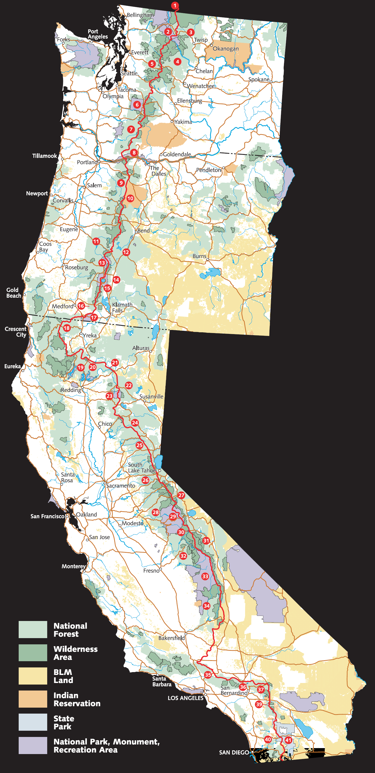
Big Bear Lake
Moosie and I arrived at Hwy 18 and hitched a ride down to Big Bear Adventure Hostel. We didn't quite make it by the weekend as we have been keeping the mileage down to make sure our bodies and joints get acclimated to the abuse that we've been putting on them, but as of this post we've been making great miles and feeling strong. After a fantastic meal at a restaurant called the Himalayan (authentic Nepalese food), we are about to go resupply at a supermarket and head back out on the trail. It was nice to sleep in a bed for a night but we're meeting Steiner and Emily on the evening of June 2nd and it's time to make some miles.
Since the last post, we've been through a little bit. We eventually climbed out of the desert and into the San Jacinto Wilderness, which gave us our first snow and ice, along with a few rattlesnakes (you can see more in our pictures). Though we packed crampons and ice axes, there were no sections that really required their usage. We lost the trail at both Little Tahquitz Meadow and Fuller Ridge but in both cases, a topographical map and altimeter were all we needed to bushwhack our way back to the trail. There's just so many use trails that footprints go all over the place and in certain sections, the trail actually lies on steeper parts of the slope so it's smarter to stay on a flatter section and make your way down.
After passing San Jacinto, we had a fun time descending 16.2 miles on the slowest switchbacks of all time into Snow Creek Canyon, then crossed the San Gorgonio Wash and the I-10. Then we climbed out into the San Gorgonio Wilderness, which I really had no idea was so incredibly beautiful. Passing a wind farm along the way was certainly surreal, and we headed into the Whitewater Preserve to meet Dave, Val and Leila for some trail magic of beers and steak fajitas, as well as a breakfast at a diner courtesy of Leila the next morning. After a slow start, we headed up Mission Creek and had a very Appalachian Trail-ish experience of constantly following a creek up and fording/crossing it multiple times. Really fun and beautiful.
After the very long ascent in and out of the canyons of the San Gorgonio Wilderness, we've made our way to Big Bear Lake and will tackle the Bernardinos and the Angeles Crest next. VERY excited to have Steiner and Emily come out and join our trail family. Kevin Lee (Pete's son and my boss) is also coming out for a weekend at the beginning of June for 2-3 days to hike some miles with us and that's going to be fun - he's had a lot of experience in this neck of the woods due to his ultra-marathoning days out here. Hopefully he doesn't leave us in the dust and just decide to meet us in Canada.
More pictures are up at the usual location.
New photos start with this one (please note that I hike with that face 99% of the time).
Much love and thanks to those who have dropped me an email or a text. It means a lot to have messages waiting for me.
Our next spot that we can receive a USPS shipment at is:
Shian Sung or Nicole Donnelly
c/o The Saufley's
11861 Darling Road
Agua Dulce, CA 91390
We will be there Sunday, June 6th. Please remember to ship USPS Priority Mail and that it will take 3-5 BUSINESS days to get there, depending on where you are shipping from.
Anyways, things are going GREAT and we've had a lot of fun so far. It's just getting started!
-Barrel Roll
PS One fun thing is that I got my jury duty notice. I sent a long letter back explaining why I can't serve this very moment. Hopefully the California government understands my predicament and will let me postpone til later this year : )
Saturday, May 22, 2010
Tuesday, May 18, 2010
Beginning
I graduated on Sunday, moved out on Monday, and fly out on Tuesday (today).
I'm headed to Tanzania to climb Kilimanjaro, and then will fly to L.A. to begin hiking the PCT. This may be one of my last long posts for a while.
Oh, and speaking of, if anyone wants to transcribe my blog entries, let me know. I'll write them out and mail them to you.
Happy trails to MC and BR. Can't wait to see you
Sunday, May 16, 2010
Introduction #2: More questions
What's a flip flop?
A “flip flop” hike is a hike that begins in the middle of an end-to-end trail, going in one direction, and ending in the other. Typically, long distance hikes are undertaken from one terminus to the other. The reasons people undertake these hikes usually has to do with weather or timing.
For example, on the Appalachian Trail, flip-floppers would start in Virginia and typically go North. The advantage is that the flip-floppers would build up stamina (“trail legs”) during the relatively flat middle portion of the trail. By the time they reached the more challenging New England section, they would be in trail shape.
Though I would have preferred a straight end-to-end hike of the PCT, I will be flip flopping the trail because of scheduling concerns. The traditional start period of the trail is late-April to early May. Because of my trip to Kilimanjaro and my graduation, I won’t be able to start until early June. As a result, I will be flip flopping,
beginning about 400-500 miles into the PCT.
What's a trail name? (i.e., why do you sign off with 'Steiner', 'Barrel Roll', 'Moose Charmer', and '[insert Emily's trail name here]'?
According to wikipedia, a trail name is a 'psuedonym'. Trail names are psuedonyms, but a particular kind of pseudonym. They usually refer to an important or memorable experience on a custom on long distance hikes, such as the AT or PCT. Hikers will introduce themselves, and refer to each other by their trail names. The custom is so ingrained that on the AT, hikers will sign registers (e.g., notebooks) with their trail names, instead of their given names.
There isn't always a lot of agreement on trail names. Here are some of my general rules on trail names. My rules are by no means universal.
- Trail names are used on the trail, always preferred to real names
- Trail names cannot be chosen by the hiker, they must be given. However they can be rejected if deemed unsuitable
- Trail names can be rejected
Earning a trail name is one of the rites of passage of long distance hiking. We all wear ours with pride, ridiculous as they are.
What are some other trail names?
One of our best friends from the AT, Bouie, had the nickname from his mom. Frogger was incredible at river crossings. Sock lost a sock while rinsing in river one day. It wasn't a memorable experience, but I think the hiker community had decided that he had gone too long without a name, and it was high time he had one.
One of my favorite trail names from the '05 AT Northbounders is "Celine Dion Sanders". I still don't know the story behind it. If anyone knows, feel free to post.
I have no idea what Emily's trail name will be yet. She may have an inkling. I certainly have some ideas, but she does have veto power. We will keep you posted.
Saturday, May 15, 2010
Zero Day!
Today is our first zero day (zero day = day in which zero miles are hiked) after ~100 miles! Sorely needed as our bodies are in need of some R&R&R&R (rest, relaxation, resupply, refuel). The trail has been fantastic but it's always nice to take a little time off to let our bodies heal up a little and get used to the miles (little do our bodies suspect the pain and suffering that lays ahead...).
Our zero day comes courtesy of trail angel Pete Lee (Kevin Lee's dad for those who know him), who picked us up at Lost Valley Truck Road and took us back to his incredible house which is filled with all kinds of incredible stuff (comes with being the director of 3 major museums along with a lifetime of awesome experiences). After a tasty pasta dinner last night, we got a great night sleep on a bed, laundry, and are just lounging around. Did I mention the shower?! Nothing is better than the shower after a week on the trail. Especially since there haven't been a ton of streams or lakes to jump in. Actually, water hasn't been a huge issue due to the heavy snow and rain we had in the spring, and every seasonal source has been running. The longest stretch without water was approximately 14 miles and we just carried more water to compensate.
I've posted a bunch of new pictures up at my public album:
http://picasaweb.google.com/shian.sung/SobohobosOnThePCT
Check it out and enjoy : ). I've added the capability to post to the blog via text messages so we'll try to get more regular updates up here via short text messages but it will depend on phone service and inclination to dig through my pack to get my phone out at opportune times. Whenever I get internet i'll try to put more pictures up!
Anyways, a comfortable chair and a cold beer are calling my name, so for now we'll leave it at this. Going into town later today to pick up food for the next week. We hope to be near Big Bear by next weekend, and a week and a half after that Steiner and Emily join us. Can't wait!
-BR
PS Anyone who wants to contact me, i'll have my cell phone on so feel free to give me a call today.
Tuesday, May 11, 2010
Warner Springs on 5/13!
I received a text from Moose Charmer today [verbatim]:
Trail is great! 68 miles so far. Veeery windy! Gonna b n warner springs thurs. Br would like u 2 post this 2 the blog
2,582 miles to go.
Trail is great! 68 miles so far. Veeery windy! Gonna b n warner springs thurs. Br would like u 2 post this 2 the blog
2,582 miles to go.
Sunday, May 9, 2010
"Return to Bear Country"
Years ago, when I told my mother I was going to hike the AT, she put her hands on my shoulders, leaned in, and exclaimed: "That is bear country!". By "bear country", she meant the entire East Coast. When I told her I was planning on hiking the PCT, she promptly dubbed the entire West Coast, "bear country". (Apparently, flyover territory is bear-free.) The way my mother sees it, it's bear country, we just live in it.
Anyhow, this post is in tribute to my amazing mother. Without her, I couldn't have hiked the AT. And, I couldn't hike the PCT without her support either.
Happy Mother's Day to my mother, and mother's everywhere.
Anyhow, this post is in tribute to my amazing mother. Without her, I couldn't have hiked the AT. And, I couldn't hike the PCT without her support either.
Happy Mother's Day to my mother, and mother's everywhere.
Friday, May 7, 2010
It begins!
Nicole is headed out now with her father, i'm following shortly to Lake Morena campground. Tomorrow morning we hike the first 20 miles back to our campsite from the Campo border.
Yikes. Another adventure. This could be an addiction.
Yikes. Another adventure. This could be an addiction.
First two mail drops
Mail Drop # 1 - Warner Springs - mile 109.6 - we should be here by late next week, don't send us anything here.
Shian Sung or Nicole Donnelly
General Delivery
Warner Springs Post Office, 92086
Mail Drop # 2 (Hikertown) - This is at mile 518.4 on highway 138, we should be here in around the end of May, beginning of June. Feel free to send us postcards, presents, snacks of your choice, cash for us to buy snacks of our choice, whatever : )
Shian Sung or Nicole Donnelly
c/o Hikertown
26803 W. Ave C-15
Lancaster, CA 93536
Shian Sung or Nicole Donnelly
General Delivery
Warner Springs Post Office, 92086
Mail Drop # 2 (Hikertown) - This is at mile 518.4 on highway 138, we should be here in around the end of May, beginning of June. Feel free to send us postcards, presents, snacks of your choice, cash for us to buy snacks of our choice, whatever : )
Shian Sung or Nicole Donnelly
c/o Hikertown
26803 W. Ave C-15
Lancaster, CA 93536
Heading to the trail
Room is empty (other than the computer, desk and futon), backpack is hopefully ready to go. Now to finish up all those LAST minute things... heading to the trail this afternoon if all is ready.
Thursday, May 6, 2010
And then there were two...
Hello All. Steiner is letting me “contribute to” (i.e. clutter) her blog space during the PCT and I wanted to take a moment to introduce myself before jumping in with bear fears and gear chat.
Me and my daddy longs hit the pacific crest trail with Steiner, Moose Charmer, and Barrel Roll on June 2nd. I’m taking an opportunity before bschool to challenge myself outside of my usual Excel universe and hopefully see some stunning views along the way. With little (closer to no) hiking experience, I am approaching this 2,650 mile trek as a series of several (20+) week-long journeys and will continue to move my pack forward only as I am learning and having fun. That being said, it is my goal to thru hike the entire PCT so I will make it a point to keep my mind busy with math challenges, books, & astronomy and focus on weekly mileage goals.
Being a quintessential oldest child, I am practical, literal, and driven. While these attributes have afforded me many incredible opportunities, my sensibility sometimes steers and I need to remind myself that life not inevitable and that it does not need to be habitual. That I can (and should) occasionally start completely new and foreign adventures, challenging myself to learn and grow outside of a traditional business or academic environment. I am also aware that not everyone has an opportunity to own their life in this way and I am thankful for such freedom.
It is for the following reasons that I have decided to hike the Pacific Crest Trail:
· To remind myself that there is more than work and school and that I am in a position to choose something outside of those sets
· To challenge myself physically
· To challenge myself in mentally and emotionally
· To experience incredibly scenery - get ready for some picture posts!
· To solidify career / life goals before jumping into bschool
· To stretch my daddy longs
While I am in the woods (desert, glaciers, etc.), it is not my intent to wholly separate myself from civilization, grow a beard, or become a hunter / gatherer (mac n’ cheese and peanut m&m’s, here I come!). I will check my cell when I can. For those friends who will be on the West Coast anytime from June through October text your date/ locations and hopefully we can meet up for a meal - I promise to try to find a shower beforehand. Postcards / packages at any point on the trail will be much appreciated and we will post our mail drops soon. Also, you can follow me on twitter @mctrail
Crunch time
Feverishly packing up all my belongings into boxes. Original plan was to really sort through my things (there's really not a lot) but now the new plan is to throw everything into boxes and worry about it when I get back from the hike.
Food strategy at the moment is 70 days worth of food packaged in 2-day increments (already done) to be sent out to strategic points via post office or people bringing food. We'll be resupplying from grocery stores and gas stations for the rest of the way, similar to what I did at the end of the Appalachian Trail after tiring of the same 3 flavors of Lipton's Noodles and king-size Snickers.
So, box everything up, finalize my pack, and... I guess i'm ready. Doesn't feel like i'm ready. I know i'll feel differently once I step out on the trail but for the moment it doesn't feel real. Nothing really has the last 3 months though.
-BR
Monday, May 3, 2010
Background reading
Books are considered a luxury on the trail, because they are heavy yet inedible. During my AT hike, I always carried books, sometimes two or three at a time. I mostly read paperbacks which were either mailed to me, or found in AT shelters or in town. I still have the torn-up copy of Edith Hamilton's Mythology  I found somewhere in Tennessee. It was only fitting that on my last night on the trail in Georgia, I reread her telling of the Odyssey.
For the PCT, I plan to carry books, too. The challenge of long-distance hiking has two components: physical and mental. On the AT, they say that the first half of the hike is physical, and the second half is mental. If you can physically bear the first half of the trip, you can probably bear the second half. The bigger question is whether or not you want to finish the trail.
It's so easy to quit--it would take a few days to hike to a road, hitch out, and get on a plane or a bus. For me, I need intellectual stimulation to stay on the trail. I plan to always carry a book, and would welcome reading materials from my friends.
As for guidebooks, there seem to be a few common books to carry. Some people carry the Pocket PCT: An Elevation Guide to the Pacific Crest Trail . I haven't heard much about this one, and many of the maps are available online from halfmile's website. I like elevation profiles, but they are intimidating, especially in the Sierras.
My plan is to carry the official data book from the PCTA: Pacific Crest Trail Data Book . This is a minimalist, pared down book, mileage markers and water locations. It reminds me of the Wingfoot book
 I carried on the AT. The PCTA also has more extensive guide books, with full maps and written descriptions of the trails. There are three books total, one for Southern California
 , Northern California
 and Oregon and Washington
 . I highly recommend these books, which are have b&w photos and are lyrically written. Water access is also described in great detail, which I will need, especially in the desert.
The books are great but heavy. I've cut up the Southern California book and have sent the sections on in the first set of bounce boxes. I'll ask my family to send the rest of them along the way.


For the PCT, I plan to carry books, too. The challenge of long-distance hiking has two components: physical and mental. On the AT, they say that the first half of the hike is physical, and the second half is mental. If you can physically bear the first half of the trip, you can probably bear the second half. The bigger question is whether or not you want to finish the trail.
It's so easy to quit--it would take a few days to hike to a road, hitch out, and get on a plane or a bus. For me, I need intellectual stimulation to stay on the trail. I plan to always carry a book, and would welcome reading materials from my friends.
As for guidebooks, there seem to be a few common books to carry. Some people carry the Pocket PCT: An Elevation Guide to the Pacific Crest Trail
My plan is to carry the official data book from the PCTA: Pacific Crest Trail Data Book
The books are great but heavy. I've cut up the Southern California book
Saturday, May 1, 2010
Introduction
I will be hiking the Pacific Crest Trail starting this June. Many people have asked many questions, so I’ll give the quick introduction below in a simulated call and response:
What is the Pacific Crest Trail?
The Pacific Crest Trail (PCT) is a foot trail stretching from Mexico to Canada on the West Coast of the United States California , Oregon and Washington
Note*: I know that “thru” to mean “through” is the essentially the same thing as writing “nite”, “kwik”, “cheez” or “krispy”. While I’m a big fan of properly spelled words, I’m going to bow to convention here.
How long will this take?
As mentioned above, most thru-hikes take 4-6 months. The rule of thumb for Appalachian Trail (AT) hikers is that it will take n-1 months to hike, where n is the # of months it took to hike the AT. All told, it should take me ~5 months. I hiked the AT in 2005, and I did keep a journal if you’re interested.
Why are you doing this?
There are many reasons to hike the PCT, which I’ll talk about over the course of the next several months. One reason is that I would like to hike the American Triple Crown, which includes the AT, PCT and the CDT (Continental Divide Trail).
What’s the plan?
Start northbound in early June. Finish in Manning Park , BC Mexico
As far as I know, the most important dates are the time of entry into Kennedy Meadows (the Southern end of the Sierras), and the finishing in Canada Canada
This is the critical test of the PCT—1940 miles completed in 122 days, averaging ~16 mi/day without rest days.
Note*: Because of snow this year, the actual entry date for Kennedy Meadows will be 6/21. For more information on how to calculate start date, see this excellent post at postholer.com
Subscribe to:
Posts (Atom)