Friday, October 25, 2013

Day 131 - Hiatus #1 Petrified forest and Painted Desert

Roadtrip!

We're going to the Grand Canyon! One day to get there, one day at the Canyon, and one day to get back to Pie Town.

Today's highlights: Petrified Forest, Painted Desert, a peek at Walnut Canyon.

All courtesy of a detailed schematic from Nita, of the Toaster House.

Thanks to Skarkle Cat for the idea, the wheels, and letting us tag along!

Mileage: 0mi

Day 130 - Pie-mania!

Pie Town lived up to its name. We had the honor of having dinner with Nita (of the Toaster House) and Ajo (of magical hats). During dinner, we had a lot of pie talk: crust preferences (thick or thin), preferred shortening (butter, lard, Crisco, or combo), thickener (flour, cornstarch, tapioca, none at all!), topping (crumb, lattice, crust), etc. I had no idea I had so many opinions on pie, but it was a rousing discussion.

Then, topped off with a very competitive game of Scrabble, which Nita took with both style points and overall score. Nita and Ajo were great company. Thanks for everything!

Also, we did a quick tour of Pie Town to look at the VLA satellite, and the windmill museum. Then followed by a slack pack in the afternoon with Masa, who is a fascinating guy. He's a Japanese hiker, and will become the 2nd Asian triple crowner when he finishes in a few weeks. He's a friend of Jackaroo, who I met on the AT and JMT. And, he's working on completing the Japan Trail, which will be 1,600+ km when completed, and stretch the length of the country. Glad we had a chance to get to know him.

Oh, and in one of those, "only on the trail" moments, someone made an offhand joke about going to go see the Grand Canyon tomorrow. And it blossomed from an offhand joke into a full-blown adventure. Another hiatus from the trail, and we'll be back on Sunday.

Mileage: ~17mi from Pie Town to the brown house on Ed Jones Rd

Day 129 - Pie Town!

I did not relish today, 32m on a mostly straight dirt road to Pie Town. The occasional passing car kicked up a huge plume of dust. One white truck stopped, and J.J. Henio introduced himself. He's half Apache, half Navaho and manages the road conditions. He gave us his address and asked us to write to him at the end of the trip so he knows the dusty hikers he met, did indeed make it all the way to Mexico.

Otherwise, not much of note. We gratefully filled our water bottles from the Thomas Mtn Ranch spigot. We stopped or lunch there, at the halfway point, 16mi done, 16mi left. John and Angie Thomas weren't there, but we had their vocal and amorous donkey for company.

I was bone tired as we kept walking. My feet are sore from roadwalking on hard baked sand. To keep our spirits up, we listened to the 5 songs, and 2 podcasts I still have on my phone.

We arrived around 7:30pm at the Toaster house to find Skarkle Cat. Home sweet home.


Mileage: 32mi from Pie Town Rd to Nita's Toaster house

Day 128 - Lava rocks, La Ventana, getting lost

This morning, I crossed 8mi of lava on the Zuni-Acoma trail, which has been around for nearly 1,000 years. It is a trail across rough, spongy-looking lava rocks ranging in size from pebbles to huge boulders. The spongy rocks look light and airy, but are actually hard as, well, rocks. And the roughness is tough terrain, like walking across a 3D buzzsaw. The most wear I've put on my shoes this trip was the short stretch on the lava, tearing out small chunks of rubber as I walked. The terrain varied, with some slabs of long, relatively flat stretches, and some stretches of loose scree with poor footing. The informational signs at both ends note that the Spaniards could not cross the lava with pack animals, even on the trail, and detoured around the area.

And yet, this is one of my favorite sections of the CDT so far. Thanks to the Mumms, I had the eyes to enjoy this section of trail. I had a real thrill walking along the winding trail, knowing that people have been crossing it for hundreds of years on this very route. The way is marked only with cairns, and I had to look cairn to cairn like a treasure hunt to navigate. We came across some signs on civilization--a semi-circle of rocks marking the foundation of an old structure, bridges of lava rock pressed tightly together to cross deep crevices. Truly a unique section of trail.

Plus, before we started the lava rocks, we came across a surprise, courtesy of Skarkle Cat. They left us some trail magic at the trailhead. Any challenge, when fueled by Sprite and donuts, seems more fun. Thanks, Skarkle Cat.

After the lava rocks, we stopped at the Mumm's next water cache at Hwy 117. We gratefully drank the fresh, clean water, which is in such short supply in the area. Thank you, Hugo and Carole!

A few miles later, we arrived at La Ventana, a natural sandstone arch. I'm terrible with proportions, but the arch must be at least 100' across. We hit it at the right time, and it was incandescent with the noon sun.

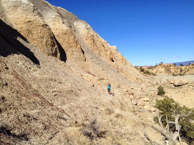
And here's where the wheels came off. The Ley maps note an alternate trail, on the rim above La Ventana. Though we had 30mi on the docket, we didn't want to miss the hike on the rim of the mesa. So, we followed the dashed line on the map, and bushwhacked up to the top of the mesa.

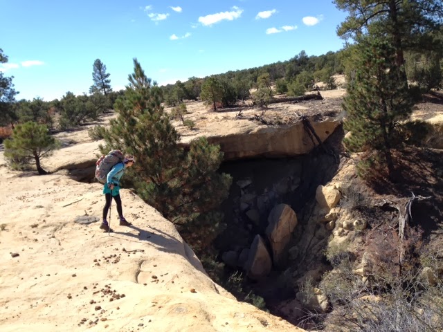
I wanted to take the all forested approach, in the center of the bowl. Gangles suggested we hug the edge of the bowl tightly, and go up right next to La Ventana, which seemed to be indicated by the map. As we climbed next to La Ventana, we crossed numerous cave dwellings carved out of the sandstone. One had a partition wall intact. Fascinating. We kept climbing, a few hundred feet, the tread becoming steeper and more rocky. From the valley, the top of the bowl looked sheer, but with enough angle that we could switchback up. By the time we arrived at the rim, we realized that we couldn't get up the last 15'. The bowl had evolved slowly into sheer, 90 degree sandstone. There were some footholds and handholds, but we were not confident enough climbers / boulderers to get all the way up. [Note: Passable if you have climbing skills; also, the better bushwhack is the forested, non-cliff route] We managed to climb with full packs partway, but couldn't climb the last 5'.

We were stuck, at the top of the bowl, with 5' of impassable cliff at top. We had to descend. It was so steep that we were sliding feet first, crab-wise, down the rocks. We couldn't descend standing up. At some point, the rock was so steep, I felt if I slid, I might go right off the edge. I braced myself and just pointed at a tree, which luckily broke my fall. On another slide, I was sliding, wedged in a crevice, but the weight of my pack was pulling me down the rock headfirst. Gangles guided me down by grabbing my leg, so thanks for the assist. I was pleasantly surprised we survived without head injuries. Harrowing.

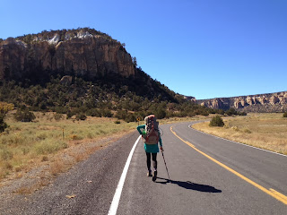
Three hours later, we were back in the same place where we started. We shook off the adrenaline and hiked as fast as we could down Hwy 117. We had to clear it by sundown, since there have been reports of drug activity on the road (small planes dropping packages, idling trucks waiting nearby, warning shots fired at CDT hiker tents).

And sitting on the side of the road...MASA! He was recovering from his cold and had set out from Grants earlier that day. We chatted for a minute, and then pushed on.

We did clear Hwy 117, and had to night hike a bit to get to Pie Town road. Long, exhausting day. While I am sitting in the tent, some truck passed and let out a shrill 'YEEHAW!'. I hope that's a friendly whoop.

Mileage: ~25-30mi from near Hwy 53 to near Pie Town Rd

Monday, October 21, 2013

Day 127- Leaving Grants...

We had a hard time getting on the road today. I think we're mentally exhausted from the first 2,400mi up to now. We lingered a little too long at our last outpost of civilization, the local McDonald's. The local citizens of Grants are so friendly. Several came over and introduced themselves, and one rancher even invited us over for dinner.

We finally got out of town, walking on the road until we came to the first canyon. During our walk, we came up with a crazy scheme: we are going to try long days to shave off a day on this stretch. This means we'll attempt to get to Pie Town in three days, 24mi, 30mi, 30mi. The biggest miles we've done since WY.

Tonight, we had to night hike, since we lollygagged in town for so long. But it was fast, easy walking on nicely groomed dirt roads. We stopped for the night near the Mumm's water cache by Hwy 53, just before entering private lands. Tomorrow is a big day, with a historic stroll over an ancient trail marked on lava rock with cairns, and La Ventana, a natural rock arch. Excited.

The stars are especially lovely tonight before the moonrise, so brightly contrasted in the desert sky. The Milky Way is clearly visible, and Gangles mentioned that it always makes her crave cereal.

Thanks again to the Mumms for their water caches. So necessary and helpful!

Mileage: 24mi from Grants to near Hwy 53

Day 126 - Happy birthday, Gangles!

Happy 29th birthday to Gangles! It is her cribbage birthday, since 29 is the highest possible cribbage combination. (I don't know what this means, I'm just transcribing her excited squeaking about cribbage, but it sounds neat)

We had a quick walk in this morning, descending the dry and cactus-y mesa to the road into Grants. We passed a women's correctional facility, and wished a good morning to the inmates on the other side. They were quite chipper. We wanted to chat more, but wasn't sure if it was kosher, and pushed on.

Grants was spread out, so we decided to end the day at the Coco Bean coffee shop so we could meet Sky and SparkleCat for lunch. SkarkleCat (Sky + SparkleCat) were the first hikers we've seen since we lost Steve in WY. Had a wonderful lunch with them, catching up on trail gossip. They kindly ran us back to the motel, where we finally met...Masa! Unfortunately, he's battling a head cold, and taking a few days off to recuperate. So, Masa is in Grants for another day, and SkarkleCat left town. We're in the bubble again, but hope to see all of them in or near Pie Town.

We also had a surprise birthday celebration for Gangles, decorated courtesy of the local Dollar Tree. Classy affair, and the event of the season.

For dinner, we had the honor and pleasure of having pizza with the Mumms, the local trail angels. They supply water for most of the hikers in the areas surrounding Grants, which is desperately dry. I almost felt like a real person, and not a hiking hobo, sitting at a table with placemats and talking about something other than the CDT. The Mumms were wonderful dinner companions and conversationalists, urbane, witty and so gracious to invite us into their home. They told us about their line of work (exquisite artisan birdcages), local explorations of ancient ruins and petroglyphs, and an epic road trip to the Ontario region. A fun and memorable night. Hugo and Carole, thank you for all you do for the hikers!

Ok, off to bed, going to try a big day out.

p.s., Is it just me, or is the CDT littered with vertebrae?

Mileage: ~8mi from mesa top near Grants to Grants

Saturday, October 19, 2013

Day 125 - Mt. Taylor

We went over Mt. Taylor today, our last time over 11,000' on the trail. And not a day too soon. Another cold night and morning--all of our water froze again. Had to wait a few hours to drink.

Beautiful view on Taylor, 360 degrees around, including the much antennaed peak La Mosca nearby. Some jokester has put up a tin silhouette (maybe Pogo?) of a cartoon on the summit sign. Many elk hunters out and about today, flashes of blaze orange zipping up and down the mountains effortlessly in pick-up trucks and ATVs.

And, thank you thank you thank you to the Mumms for their water cache at FR 193 & 501. Much needed.

Into Grants tomorrow am for Gangles' birthday!

p.s., Can't believe we've been on the trail for 125 days. 5^3. Let us get off this trail before we hit the next cube.

Mileage: ~25mi from near Lower American Springs to near Mt. Taylor trailhead

Friday, October 18, 2013

Day 124 - Stones in the road

Spent most of the day on the forest roads which comprise the official trail. Uneventful. Some hunters gave us water. The road was rocky. We spent the day chatting and making miles.

Today felt like an interstitial transition day, between the alien landscape of the past two days, and the upcoming climb up Mt. Taylor.

Mt. Taylor is not on the "official" CDT, but according to Nobos, the far more popular route. The "official" route skirts the mountain on a trail to the North for no apparent reason. Maybe because the mountain is considered sacred to local indigenous people? Who knows? I am excited to climb to 11,000'+ one last time on the trail. Then balmy valley temps all the way to Mexico. Right?

p.s., In June, there was a report of a "friendly" mother bear and two cubs near this spring. Am a bit jumpy, but it is rifle hunting season, so hope that keeps the wildlife at bay

Mileage: 28mi from near Seco Tank to near Lower American Springs

Thursday, October 17, 2013

Day 123 - Greetings from Mars

At some point today, we lost the thread of the trail and wandered off into the desert scrub. I came across the eviscerated carcass of an adult cow. The still furry red hide was drawn tightly over the intact skeleton, like some macabre tent. I would have taken a photo, but I almost retched. The death was recent, the bones unbleached but the flesh already consumed probably by coyotes, then by raptors and insects.

And less then a mile later, amid the harsh dry landscape, a reassuring sign of life--a herd of five wild horses: white, strawberry roan, grey and white paint, bay with black points, bay with a white blaze and stockings. All different coats, yet in one family unit. When I approached, the horses didn't startle, but drew near each other, their tails towards the center, and their heads spread out in a fan formation, watchfully monitoring my progress past their territory. We passed, quickly for us, too slowly for the horses, and the horses went back to grazing.

Signs of decay and vigor so close together, a reminder of how quickly life cycles through the desert environment.

Beautiful walking today, up and down mesas, winding through still alien rock formations.

Water far apart in this section, ~15-17mi between good sources. Long day today, but continuing to crawl towards Grants.

Mileage: ~26mi from near Deadman Peaks to near Seco Tank

Wednesday, October 16, 2013

Day 122 - Pitch Black

One of my favorite movies is "Pitch Black", a movie about a spaceship crash landing on another planet. It stars Vin Diesel and Radha Mitchell, and helped launch both of their careers. I'm not a huge sci-fi fan, but I love this movie because the sets of the foreign planet are beautiful, like MoMA beautiful. Check out some production stills. And even more amazing, the set isn't an anonymous soundstage in Burbank, it is Australia! The alien right here, among us on earth.

Just like New Mexico. The desert here is beautiful and barren looking--oddly shaped rocks, deep crevices, all lit under the klieg light of a cloudless sky. And strange bits of movement in the corners of my eye, an almost perfectly camouflaged tan bobcat running into the sage. Little whirling dervishes of dust cyclone upwards in tight cones. Almost easy to imagine we're not on earth.

And this is so strange, since we're only ~25-30mi from Cuba, NM.

We left the Del Prado hotel this morning, after the wonderful hospitality of Mrs. Yang and her son Daniel. Wish we had been able to spend more time with them, but the trail calls.

The hike begins with a roadwalk, then we veer off to the left into the sand and sagebrush. The trail climbs up to a mesa, and we walk along the edge, with spectacular views of the valley below. Eventually, we descend from the mesa to the valley, and intersect some BLM roads.

Just as we stopped to plot where we were going to collect water, a passing white pick up truck slowed to a halt. The three guys were curious about what we were doing. They offered us a ride to Mexico, Grants, wherever we wanted to go. But, we have a continuous footpath, and no hitching, so we passed. Then they offered us water, and Dr. Pepper (a sign that we are getting closer to TX?). Real, fortuitous trail magic from real angels. Thanks guys.

With ~20m of sunlight left, we crossed a section of trail where someone had spelled out "hi" in rocks. Took it as a good sign and decided to camp here, on a broad, flat expanse of sage. No wind cover, so the tent is shivering in the gusts. It is going to be a cold night, something in the 20s. Glad we got fleece liners.

Incidentally, the combination of the cold and dust has given us both bloody noses. We may need to get this checked out in Grants.

Oh, and there is the small matter of Gangles' birthday on October 20. We're aiming to be in Grants on that day.

Mileage: ~28mi from Cuba to near Deadman Peaks